News of the day pertaining to the sinkhole in Louisiana... first a recap of recent posts......
http://fredw-catharsisours.blogspot.com/2013/01/killer-lake-syndrome-might-this-be-what.html
and....
http://fredw-catharsisours.blogspot.com/2013/01/louisiana-sinkhole-updates-monday_21.html
and now on to yesterday and today's items of note ... h/t Louisiana Sinkhole Bugle , Freedomrox and On Wings of Care.....
http://lasinkhole.wordpress.com/2013/01/28/all-out-effort/
and......
http://lasinkhole.wordpress.com/2013/01/28/incident-action-plan/
http://freedomrox.wordpress.com/2013/01/27/louisiana-sinkhole-updates-technology-and-theory/
If ‘Officials’ had backed off when they noticed the seismic events, and the casing pressure rising at the Oxy 3A OBW to over 923 psig, then the event would have settled within days. Instead they kept it up, then proceeded to finish it off with the T-Rex tri-axial array, and render any and all readings taken to date useless.

http://onwingsofcare.org/protection-a-preservation/humanitarian/356-20130126-bayou-corne-owoc-flyover.html

http://fredw-catharsisours.blogspot.com/2013/01/killer-lake-syndrome-might-this-be-what.html
and....
http://fredw-catharsisours.blogspot.com/2013/01/louisiana-sinkhole-updates-monday_21.html
and now on to yesterday and today's items of note ... h/t Louisiana Sinkhole Bugle , Freedomrox and On Wings of Care.....
A Good “What If” Video
LINK – http://youtu.be/N5togm6nrHo
http://lasinkhole.wordpress.com/2013/01/28/all-out-effort/
All Out Effort to Get the Word Out About the Sinkhole – Super Bowl, Oscars Soon
ITEM: Sunday the SUPER BOWL will be broadcast FROM NEW ORLEANS.
ITEM: Soon (Feb. 24) the ACADEMY AWARDS will be on tv and BIG CONTENDER FILM IS FROM LOUISIANA and stars a cute kid FROM LOUISIANA.
This is a great opportunity for everyone to use social media, message boards, fantasy football chat rooms etc., etc. to spread the word about this big disaster. We must break this media black out if the Bayou Corne residents are ever going to be compensated for their ruined homes. This summary mash-up video is great link to pass on:
LINK – http://youtu.be/8gZYg4_usnI
The Superbowl hash tag is #BS47 or #CBSSUPERBOWL
The Academy Awards hash tag is #OSCARS
If you get tired of making up tweets try this sinkhole message generator.
short link to this page - http://wp.me/p2GNDM-1Gl
and......
http://lasinkhole.wordpress.com/2013/01/28/incident-action-plan/
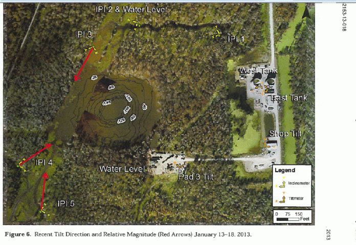
Jan. 21 Incident Action Plan with TILT Meters
check it out - Industry & Investment NSW Incident and Action Plan

CLICK ON IMAGE FOR FULL SIZE

As usual, thanks to Freedomrox for this. “The graphics show Well Pad 3 dropped almost six and a half inches”
http://freedomrox.wordpress.com/2013/01/27/louisiana-sinkhole-updates-technology-and-theory/
Louisiana Sinkhole Updates, Technology, and Theory
****
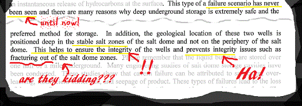
Everything everybody thought they knew about the Louisiana Sinkhole changed with the latest ‘Belch’ event on January 19th, 2013, for the geology that existed prior, no longer exists.
This is a whole new animal we are now dealing with. With an overburden of water, the combination of the ‘thumper trucks’ performing a Vertical Seismic Profile (VSP) for the five days prior, and then Friday the ‘T-Rex’ Tri-Axial set off a chain of events, that has moved around the rock structures, and allowed new migration zones for the formation gas, and even the bedded gas from the salt edge, (whatever is left of it at the top), and that the prior VSP readings are now completely useless.
If ‘Officials’ had backed off when they noticed the seismic events, and the casing pressure rising at the Oxy 3A OBW to over 923 psig, then the event would have settled within days. Instead they kept it up, then proceeded to finish it off with the T-Rex tri-axial array, and render any and all readings taken to date useless.
Nothing is the same underneath this disaster area as it was. If this had been performed in September, then this whole situation may have been mitigated by now.

“Hoffpauir, a technical staff associate with the University of Texas’ Geotechnical Engineering Program, said the diesel-powered T-Rex, which has 6-feet tall wheels, can send seismic waves into the ground in three dimensions, or tri-axially, from a central vibrating plate.
“It’s the only one in the United States” that can do that, Hoffpauir said.”
And;
“The waves started at a low frequency and quickly picked up speed, sounding something like a car engine revving from low to high revolutions. From behind the well, mild vibrations could be felt in the earth at the lowest frequencies but they dissipated at the highest frequencies.”
That is precisely how you set up resonance, and this after, five days of;
“A less versatile type of vibroseis truck, called a thumper truck, was used recently, Texas Brine officials said.”
“A less versatile type of vibroseis truck, called a thumper truck, was used recently, Texas Brine officials said.”
“Texas Brine plans to do the most intensive seismic testing of all, 3-D seismic tests across a swath of the Bayou Corne area next month.
Expected to deliver a picture 7,000 feet deep, these tests may show whether any feared voids exist underground and the location of oil and gas traps.”
What form of 3-D testing or with what tools is not being disclosed at this time.
As this author reported on various websites on January 20, 2013;
Well venting gas is beyond belief in its surge! Low Pressure, high volume.
Great pictures of the damages at Well Pad 3, and they are plugging and Abandoning MRAA#3. That’s the aquifer vent and monitoring well close to Oxy 3.
This is ORW 12
OXY 3 Well Pad is royally screwed.
This also means there was extensive rock and possibly salt movement during this ‘belch’. It’s found a new path for the gas to migrate. Lots of rocks have shifted and changed position. This is not good news for the Crosstex Cavern 2.
More rock movements are being shown on all borehole heli’s and this event is not over. It is building up for another event…mark my words. This was not a burp, it was a belch and did a lot of damage. I would not be surprised if the salt is now laying twenty to thirty yards further west now and brining out, taking with it a good portion of the stability of the west side of the dome.
Many were claiming it was impossible that the Vertical Seismic Profile, along with the overburden of water over the thin layer of soils and claytard, to be causing the seismic activity that I based my earlier warnings upon.
Seems Dr. Stephen Horton, with the University of Memphis doesn’t agree with the naysayers.
“Recent seismic activity is possibly contributable to VSP activity or the unusually high water, according
to Dr. Horton (1/16/13)”
to Dr. Horton (1/16/13)”
(Page 15)

Seismic Visual of the Event on January 19th, 2013 from Helicorder LA08.
AUTHOR’S THEORY:
Many questions have arisen as to why it was vital months ago to find out what the water flow rates were and what path it had taken. If there was just one water source in, then it would just brine an area out, no big deal. That does not seem to be the case here. Allow me to postulate..
First, we have the fracked out cavern full of brine spilling outwards towards the formation waters that is pushed upwards under 7-9000 ft. of overburden pressures, which dilutes the brine and pushes it with ever increasing frequency back towards the breached cavern zone.. Once brined out the pressures force the Formation Waters upwards and eroding the Salt Flank in pockets.. how far? We don’t know.
Then we have the subsidence area that has punctured into the aquifer, and a blowout of the bottom of the aquifer where the caprock broke off is just about a certainty, or there would be no communication with the oil formation, gas, and waters below, nor would methane be able to swell the aquifer.
So we have infiltration from the top of the salt rock from the bottom of the aquifer and under a part of the caprock, (entry from the broken section of caprock), which is most likely brining out into the voids, allowing fractures and large pieces of salt rock to continue breaking off and tumbling below. This in turn gives more space for the waters to continue eastward infiltration and salt rock fractures.
Evidence for this is shown by the recent cracking of the Oxy 3 Well Pad. So, we have infiltration from above, the west side flank, and beneath, with crushed rock and liquids banging around and changing the geology daily.
So, high pressure liquids underneath, pressuring upwards on the sides, and overburden pressures squeezing the aquifer where the caprock broke off, and nothing but water saturating the whole of the overburden that could easily be migrating into these fractures from above the aquifer and any other damaged sections around these cavern wellheads causing salt blowouts in-between.
Remember the funnel of Lake Oxy 3 is determined by nothing but natural materials and fill, and not by a Cement Casing as a Well is…. Make your own mind up, but I believe this theory will be borne out by the surveys they will never allow us to see, at least not in a timely fashion.
TECHNOLOGY:
Many of these questions could easily have been answered early on by using a very well known tool and just what Representative Joe Harrison, (La. District 51), was stating at the November 08, 2012 Residents Meeting.
Louisiana State Representative Joe Harrison:
“I’m gonna tell you something, the infrared satellite vision that they have, these things can tell you more than you ever imagined. I learned a lot about that during the BP thing. At the base where they’re at, they can tell you more things and actual chemical compound makeups with their equipment than I ever imagined they could. And they’re doing that right now, it’s being monitored.”
Resident 1: They’re doing it through infrared?
Harrison: Yes ma’am they’re just not giving us the information.
Resident 2: Who is they?
Harrison: The federal government [...] This thing just seems to escalate [...] They need somebody to tie it all together [...] It needs to be declared a disaster. Once it’s declared a disaster, a whole new set of rules and regulations are enforced. [...]“
What I truly believe Rep. Harrison was talking about is a very well known technology called radar interferometry taken by the VHP Interferometric Synthetic Aperture Radar (InSAR), you can learn all about it here:
InSAR’s monitors ground deformation, as well as ground based technology, taking gravity measurements using a Scintrex CG-5 gravimeter, such as those used just after the dramatic slough in of the Daisetta, Texas, May 7, 2008 Sinkhole. (Footnote: 1)
There are many such technologies available that can give the residents and the rest of the Public some much needed answers about the voids underneath, and the topography and low level subsidence over the whole of the salt dome.
Yet, it’s the methane, total dissolved solids, total dissolved chlorides and methane bearing waters with hydrocarbons that are being transmitted all over the area, and all the way down to the Gulf of Mexico, that makes this a National Emergency, and a tragedy, ecologically, environmentally, as well as the human toll upon people West, East, and South, of Bayou Corne that are being poisoned even as we speak.
It is time for answers, and since that cannot be achieved at the State level and it has been shown that this local disaster clearly qualifies as a Federal Disaster Area, then Public pressure needs to bear down upon ALL PARTIES INVOLVED, until such an emergency is declared.
It is time for this farce to end.
Footnote 1:
PRELIMINARY INVESTIGATIONS OF SUBSIDENCE, COLLAPSE, AND POTENTIAL FOR CONTINUED GROWTH OF THE DAISETTA SINKHOLE, LIBERTY COUNTY, TEXAS
http://onwingsofcare.org/protection-a-preservation/humanitarian/356-20130126-bayou-corne-owoc-flyover.html
2013 January 26 Saturday
Bayou Corne, LouisianaFive weeks after our last update of December 24 on the Bayou Corne sinkhole, we are finding that things actually look a bit worse. The water levels seems higher, and the work efforts appear to have subsided. Equipment has been removed, and the homes to the west and northwest of the sinkhole look seriously unpopulated. The recent seismic activity has people and the government concerned, and evacuees cannot expect to be able to return to their homes or communities any time soon.
The following Google Earth maps of our flight track show the background as it looked long before this sinkhole developed (the image is stamped with "©2013 Google" but the Google image was not taken in 2013!). The blue line is our flight track; each photo is a progressively tighter zoom in. The third photo of the sinkhole in this group will give you a quick idea of how much the immediate area has changed, and how large a sinkhole has developed where previously there was none. Many more photos plus a video are included below.
Concerned citizens have kept information flowing with Facebook and email, and many have posted regular aerial videos on youtube (see, e.g., this summary of videos between August 2012 and January 2013). Please see our December 24 and August 13 articles also for comparison with our prior photos and videos.


Crosstex “Butane -R-Us” has had a Free Pass from DEQ Since August – WHY??
From The Advocate, AUGUST 16th -
DEQ seeks salt cavern butane scenario
By David J. Mitchell
The Louisiana Department of Environmental Quality has asked the operator of a salt cavern near a sinkhole in northern Assumption Parish to describe what would happen if all butane that could be held in the underground storage facility were released to the surface, state officials said Tuesday.
DEQ Secretary Peggy Hatch asked for the updated worst-case scenario from Crosstex Energy LP of Dallas by close of business Wednesday after reviewing the company’s current risk management plan for the cavern, state officials said in a news release.
The Crosstex salt cavern, which holds 940,000 barrels of liquid butane under pressure, is 1,600 feet from the sinkhole on the adjacent Texas Brine Co. LLC property south of La. 70 south. . . .
Crosstex’s rather idiotic letter dated AUGUST 15th has NOT BEEN UPDATED SINCE.

Officials: Sinkhole butane explosion possible
Weekend News – Sinkhole Trickles Up the Media Vine
Thanks, readers! You topped 300,000! Who says the sinkhole isn’t ‘news’?
Conn. Post - La. lawmakers to discuss sinkhole in Feb.
BATON ROUGE, La. (AP) — Louisiana lawmakers are planning to hold a joint meeting of the committees in mid-February about the large sinkhole in northern Assumption Parish.
State Sen. Rick Ward III, vice chairman of the Senate Natural Resources Committee, tells The Advocate (http://bit.ly/10T0CK8 ) the joint hearing, which he said has been discussed for months, would likely be held at the State Capitol.
Health Dept. Gives NEW Update
– but leaves OUT all the information!
The Louisiana DHH’s new Bayou Corne situation update has what they tested for but NO info on the results. Notice NO testing for radioactive elements. Don’t worry. They say nothing in Bayou Corne poses a health hazard.
Crosstex has a Jan. 20 update listing the status of their butane cavern about to be leaned on by next-door-neighbor-cavern.
-Well #1 – 2,897 barrels of propane
-Well #2 – 146,231 barrels of normal butane
-Well #2 – 146,231 barrels of normal butane
By now they may be nearly done with their product migration from Well #1 to (too close by our estimate!) Well #2.
FYI -
The info on where the road dept., DOTD, has Bayou Corne survey points to measure ground movement is on this page.
- What’s in the Acadian gas pipeline at Bayou Corne.
- What’s in Chevron’s pipeline there.
- Crosstex has not updated their worst-case scenario SINCE AUGUST!
- Crosstex has some interesting things in their gas samples. . . bis (2-ethylhexyl) phthalate with your water? Yum!
- What’s in Gulf South pipeline.
- Where Florida Gas’ 12″ pipeline goes
.
The Story So Far: New bubbles and ground cracks appeared near Louisiana sinkhole
From The Watchers -
By chillymanjaro
[snip] . . . . “A great sinkhole occurred on August 3, 2012 and since then it reached size of 8.5-acre. On August 3, the size of the sinkhole was said to be approximately the size of two football fields. Heavy rains last week caused another collapse. Several trees on the southern perimeter sloughed into the sinkhole on January 20, 2013.
Observations indicate that the current growth event is centered on the east side of the sinkhole – possibly related to shifting of salt and material withinthe cavern collapse zone. After a period of heightened activity, the number and strength of sharp seismic events dropped markedly following the release of debris and hydrocarbons from the sinkhole. . . . . “