Trans-Pacific Partnership Deal Guts Enviro Laws – WikiLeaks
The Environment Chapter of the deal exposed.
Secret Trans-Pacific Partnership Agreement (TPP) – Environment Consolidated Text
Today, 15 January 2014, WikiLeaks released the secret draft text for the entire TPP (Trans-Pacific Partnership) Environment Chapter and the corresponding Chairs’ Report. The TPP transnational legal regime would cover 12 countries initially and encompass 40 per cent of global GDP and one-third of world trade. The Environment Chapter has long been sought by journalists and environmental groups. The released text dates from the Chief Negotiators’ summit in Salt Lake City, Utah, on 19-24 November 2013. . . .
(whole article and TPP chapter contents)
STOP THE TPP! see Flush the TPP website.
Sinkhole items........
Texas Brine Contingency Plan – The Digest Version
We took a look at the plans for the berm moving and other things in Texas Brine’s Contingency Plan and made this summary -
Page 5 -
“The TBC team responsible for hydrocarbon management at the sinkhole has reported that there has been no new release of hydrocarbons observed since late August 2013. Oil sheens have been seen since that time has been attributed to trapped oil in the floating vegetation (!!!).”
“The TBC team responsible for hydrocarbon management at the sinkhole has reported that there has been no new release of hydrocarbons observed since late August 2013. Oil sheens have been seen since that time has been attributed to trapped oil in the floating vegetation (!!!).”
Like the “swamp gas” fairy tale we seriously DOUBT drops of oil stuck in the plants makes the sheen across Lake FUBAR.
ALSO on p. 5 -
“Over time, it is possible that the hydraulic connection between the sinkhole and the MRAA will cease as the portions of the MRAA[Mississippi River Valley Alluvial Aquifer] that are exposed in the sinkhole become sealed off by deposited sediments from the surface.”
“Over time, it is possible that the hydraulic connection between the sinkhole and the MRAA will cease as the portions of the MRAA[Mississippi River Valley Alluvial Aquifer] that are exposed in the sinkhole become sealed off by deposited sediments from the surface.”
SO . . . all the crud will NOT contaminate the aquifer because some mud will seal it all in!
Except for the “Non-aqueous liquid petroleum hydrocarbons” which will all go right to the surface. But they collected all that stuff already. So nice! For Texas Brine.
Except for the “Non-aqueous liquid petroleum hydrocarbons” which will all go right to the surface. But they collected all that stuff already. So nice! For Texas Brine.
Page 8 – You will be relieved to know Bruce Marin is in charge of everything at Lake FUBAR and his second in charge is United Brine’s Mark Cartwright. 2 unbiased, independant actors in the drama.
Page 12 – They have all sorts of monitors (Inclinometers, Tiltmeters and Water-Level Transducers) but we know at night and on weekends and holidays there is mostly no one watching them. Sometimes in broad daylight it looks like no one at the site is noticing big movement on the helicorders.
Page 14 – Nervous residents can RELAX! Texas Brine inspects the integrity of the levees every WEEK!
Page 40 – They will sample the surface water 4 times a year.
Page 52 – They want to lift the evacuation order eventually(!). “The Blue Ribbon Commission (BRC) Gas Group recommends that reducing and maintaining methane gas formation pressures in the Mississippi River Alluvial Aquifer (MRAA) to equal to hydrostatic pressure across the Bayou Corne gas area as one metric necessary in order to lift the mandatory evacuation
order.”
order.”
Page 54 – They will test for Strontium in the water. We wonder if that would be naturally occurring strontium or the radioactive waste kind.
Page 56 – They can only measure the depth of Lake FUBAR using the line dropped in method to 500 feet!
Page 57 – They’re thinking about a GPS gizmo but can’t decide to buy one yet.
Page 58 – No on site helicorder monitoring is mandated. It’s just recommended. No 24/7 in-person monitoring. “A competent and knowledgeable person should monitor helicorders when personnel are working on the sinkhole.”
Page 78 – hmmmm . . . “There are no total maximum daily load limits for pollutants in the swamp where the Project site is located or in Bayou Corne downstream of the Project site. TBC is not anticipated to contribute to pollutant loadings because storm water controls are designed to prevent pollutants associated with construction activities from reaching Bayou Corne.”
Page 93 – a side view of what the berms look like.
Page 109 - How they deduce Lake FUBAR will stop spreading.
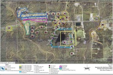
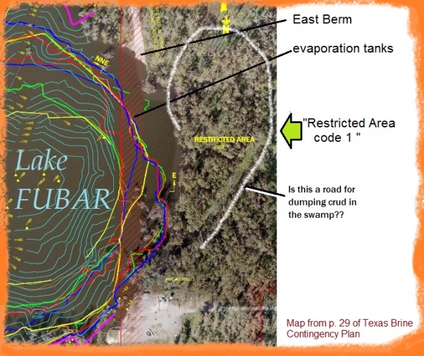
Big MAP – p. 26, p. 90 (site as of April, 2013)
On the page 26 map we saw this oddity east of the evaporation tanks -
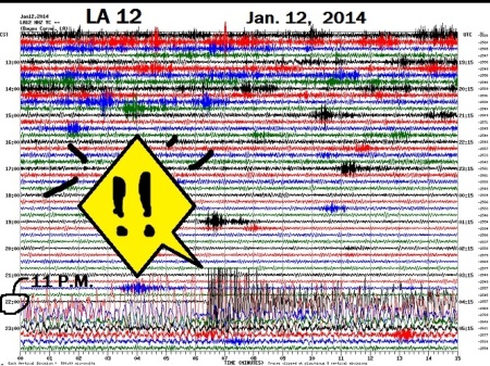
Wed. News – Seismic Rumbles All Night
The parish officials know “subsurface activity near sinkhole/Oxy 3″ and they STILL allow Crosstex to store the butane near there and they call it a CODE1. They means if anything happens they are fully responsible for workers’ well-being and nearby motorists etc.
Deborah Dupré - La. sinkhole danger: Officials to reveal methane gas concerns
LA12 gets jumpy after 11 p.m. and doesn’t stop for about an hour and a half.
UPDATE - Deborah Dupré points out this big jump was
because of the earthquake in Puerto Rico.


Good morning and thanks for all the links,
ReplyDeleteLake fubar sounds still fubar'd to me. Interesting to see the connection to the Puerto Rico earthquake. Hmm, Puerto Rico showing up in a story again,strange.
China almost sounds like they are ready to make an economic move, more gold in less credit out. Crazy times we live in.
Morning Kev ! Lake Fubar just keeps growing and growing like Topsy .....
DeleteChinese shadow banking growing like Topsy too , at least until the end of this month .....
Just put up a Bitcoin post , you will find the news interesting......
Off to Scranton again in about ten minutes ( 4th trip in less than a week for business... )
Thanks for posting this Bayou Corne news. If it all caves in and the butane blows up the winter will be very harsh for the northern states (natural gas grid will be destroyed).
ReplyDeleteSolar wind was 800kps (1.8mmph) when PR had their quake and aftershocks have continued there in the Port of Ricco. Normally the solar wind is a 3rd of that.
DeleteThe solar wind was the backdraft of the cme from sunspot 1944's X1.2 flare, that big sunspot after new year. The sun spot formed on the other side of the sun during the planetary alignment on new year. Mercury was on that side and we were between Venus and Jupiter on this side.
The next solar party may be in Feb/March when Mercury comes around again. The planetary set up for that is similar to when the solar storm happened tn '05 around when Katrina/Rita were rockin the GOM. During that storm, there was an X 17 and 40 other note worthy flares. The planetary set up is not exacty the same,but similar,also the sun's mag field strength is now much lower.
After that, it goes divergent again...good !!! ;-)
NW