Fight! Fight! Crosstex is Suing Texas Brine. Stocks Tank.
13
The Advocate – Cavern operator hit with sixth lawsuit in sinkhole dispute
By David J. Mitchell
NAPOLEONVILLE — Crosstex Energy Services LP has sued the operator of a failed salt dome cavern suspected of causing a 15.1-acre sinkhole last year in Assumption Parish and forcing the permanent closure of a Crosstex natural gas pipeline.
Filed April 22 in the 23rd Judicial District Court in Assumption, the lawsuit claims cavern operator Texas Brine Co. of Houston knew or should have known the salt dome cavern was defective and alleges the resulting harm could have been prevented.
The suit seeking damages is the sixth filed in state and federal courts over the growing swampland sinkhole between the Bayou Corne and Grand Bayou communities.
Crosstex became the first among several companies operating caverns in the Napoleonville Dome to bring suit against Texas Brine. Other suits filed so far have been brought by evacuated residents or owners of large tracts near the sinkhole. . . .
Crosstex Energy LP Stock Rating Lowered by Zacks
“Zacks downgraded shares of Crosstex Energy LP (NASDAQ: XTEX) from a neutral rating to an underperform rating in a report issued on Monday, Stock Ratings Network reports. “
On Texas Brine ‘Updates’ & Wed. News
A new “fact sheet” from Texas Brine – they are sticking to the swamp gas story.
The 3 places to find Texas Brine “updates”. Not where you think they are.
Main update page. Where they claim they inform the public but has the least information.
Then on the DNR‘s page “All Bayou Corne Updates“, select “Daily Reports” > selcect “Texas Brine“.
A hidden extra page with some sample data (sometimes and with vague information) is found by going back to the DNR “All Bayou Corne Updates” page and skipping the useless, never updated “Texas Brine Drilling Operations” page and instead selecting “Plans and Reports” and you get “Texas Brine Operation Reports” where they often have 2 interesting items; a Daily Reportand a letter to DNR about how in-compliance they are. And those letters are signed by …. Veep, Bruce Martin!
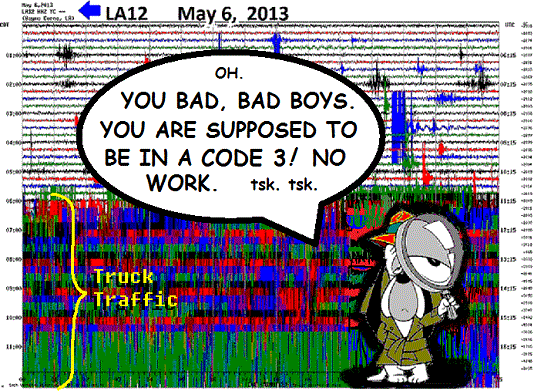
Terrific seismic activity continued overnight and the crews are working in violation of the Code 3 order as evidenced by this LA12 chart. All the charts look like this. Not even bothering with a Droopy dog cartoon.
GUIDE
GUIDE
Gong Show Continues Monday – Huge Activity
All helicorders showing big underground activity at Lake FUBAR.
LA 12 this morning -

Place your bets!
1 p.m. CST -
Heavy truck work has resumed!
DURING THE CODE 3!
http://enenews.com/scientists-worried-fears-methane-could-be-continually-fed-from-sources-below-giant-sinkhole-may-be-at-least-8-sources-of-gas-texas-brine-claims-its-played-out
[...] Scientists have worried since last fall that this deep reservoir of gas could eventually move up closer to the surface, pass through the foundations of homes or accumulate under enclosed crawl spaces in homes, posing an invisible risk for explosions in the community [...]“The deep gas displacing the shallow swamp gas, appears to be occurring,” Gary Hecox, a CB&I hydrogeologist working on the sinkhole for the Louisiana Office of Conservation, told residents in a meeting last week. [...]Texas Brine officials said their highly detailed seismic survey of the area shows only one possible source for the deep gas, known as the Big Hum, and it is played out. [...]Don Marlin, the state Office of Conservation’s expert hired to review Texas Brine’s seismic data, has raised the possibility of at least eight sources for the gas based on less detailed seismic data from 2007.This has raised fears that the gas in the aquifer could be continually fed from several sources. [...]
Seismic Gong Show at Lake FUBAR and more
These are NOT mini-quakes! And they shouldn’t be work trucks (Code 3 in effect).
Pick any spot – http://folkworm.ceri.memphis.edu/heli_temp/

The Advocate – Some work halted when tremors hit Assumption sinkhole
“Don Marlin, the state Office of Conservation’s expert hired to review Texas Brine’s seismic data, has raised the possibility of at least eight sources for the gas based on less detailed seismic data from 2007.
This has raised fears that the gas in the aquifer could be continually fed from several sources.”
This has raised fears that the gas in the aquifer could be continually fed from several sources.”
DNR has NO info from companies (who are supposed to provide DAILYupdates) for May at all.
12:15 p.m. Advisory from the Office of Conservation
The Office of Conservation, in consultation with Assumption Parish Incident Command, is advising the public that the Oxy 3/sinkhole monitoring alert status has been raised to Code 3 – requiring all work directly on the sinkhole, Oxy 3 pad and within the containment berm to cease until further notice. Seismic monitoring had detected a sustained increase in the trend of micro-earthquake (MEQ) activity in the area around the sinkhole and Oxy 3 over the past week, and a marked uptick in MEQs in the past day.
Change of Code on a SUNDAY!
TRANSLATION:
The Office of Conservation, in consultation with lawyers and political hacks, is advising the public that the Oxy 3 MESS status has been raised to Code 3 – requiring all work directly on the sinkhole, Oxy 3 pad and within the containment berm to cease until further notice.
Seismic monitoring had detected a sustained increase in earthquakes in the area around the sinkhole and Oxy 3 over the past week, and a marked uptick in man-made earthquakes in the past day. This pattern of seismic increase has been identified as an indicator of likely shifting and caving-in of the giant sinkhole and the area below it, based on past observations.
The seismic activity is limited to the Oxy 3 disaster area, showing no indication of impact to the Oxy 1 area. . . we hope, hope, hope. . . because otherwise our asses are COOKED! Monitoring is constantly (during commercials on ESPN) ongoing in the area from a really safe distance by laptop connection and those cameras we keep secret. Conservation will advise the public of significant changes in subsurface conditions or maybe not. We have some photoshop guys who fix up charts real good!
http://lasinkhole.wordpress.com/2013/05/03/code2/
Code 2 at Lake FUBAR
4:05 p.m. Advisory from the Office of Conservation(Annotated!  )
)
The Office of Conservation, in consultation with Assumption Parish Incident Command, is advising the public that the Oxy 3/sinkhole monitoring alert status has been raised to Code 2 – requiring all work directly on the sinkhole to cease until further notice.
Seismic monitoring has detected an increasing trend of micro-earthquake (MEQ) (that’s earthquake activity) activity in the area around the sinkhole (you mean collapsed salt dome) and Oxy 3 over the past few days. Such activity has previously been noted as a likely indication of shifting and sloughing in (cave in)the sinkhole and the area below it. The seismic activity is limited to the Oxy 3/sinkhole area, showing no indication of impact (really??) to the Oxy 1 area. Monitoring is constantly ongoing (except evenings, weekends and holidays) in the area and Conservation will advise the public of significant changes in subsurface conditions. (unless they happen on a weekend, holiday or at night)
CODE 2 definition -
- No visiting Gator Gold Casino during shift.
- NO SMOKING – after 4 p.m.
- NO WORK ON SITE – except on berm roads, flares, observation wells, well pad building and liner work.
David J. Mitchell at The Advocate has a detailed story on it - Micro-seismic earthquakes halt work at sinkhole
http://theadvocate.com/news/ascension/5883561-123/some-work-halted-when-tremors
Some work halted when tremors hit Assumption sinkhole
Another moderate increase in tremors near the Assumption Parish sinkhole has prevented work on the 15.1-acre swampland hole since Wednesday, parish officials said Friday.
Known as micro-seismic earthquakes, officials say the tremors have not signaled more edge collapses are imminent in the gradually growing sinkhole between the Bayou Corne and Grand Bayou communities.
John Boudreaux, director of the parish Office of Homeland Security and Emergency Preparedness, said the numbers of tremors have “not always” increased from the current level to the stage that usually ushers in edge collapses and burps of gas, crude oil and debris in the sinkhole.
“It’s going to really depend on the amount of events,” Boudreaux said.
The last slough-in and burp happened in mid-April after micro-earthquakes reached a frequency greater than the latest episodes.
Texas Brine, state and parish officials have said the tremors and surface slough-ins occur normally as the sinkhole finds its final shape and size.
The latest uptick in tremors comes as the evacuation order for 350 residents near the sinkhole hit its nine-month anniversary Friday.
Officials with the Louisiana Office of Conservation said Friday that devices measuring seismic activity have picked up “an increasing trend” in tremors associated with breaking rock and rock movement during the past few days.
Conservation and parish emergency officials halted work on the surface of the sinkhole as a result of the tremors.
Work elsewhere has continued while the micro-earthquakes were ranging from 10 to 50 per day.
The subsurface tremors are being detected around the sinkhole and Texas Brine Co.’s failed Oxy Geismar No. 3 salt dome cavern.
Scientists think the Texas Brine cavern was carved too close to the outer face of the Napoleonville Dome.
As a result, the cavern had a sidewall failure at a depth of 5,600 feet, allowing millions of cubic yards of rock to flow from outside the dome into the subterranean cavern and trigger the surface sinkhole. The cavern continues to fill with material surrounding the salt dome.
Earlier this week, Gary Hecox, a CB&I hydrogeologist working on the sinkhole, said past micro-earthquakes happened at the top of the Texas Brine cavern at 3,400 feet deep and at about 1,000 feet in the caprock on top of the Napoleonville Dome.
Movin’ On Up! Methane Migration Described in Part 6 of Community Meeting Videos + Speculation: Volcanic Gulf
Part 6, 1:30 min. mark -
LINK – http://youtu.be/CVE4qGSZyKM
And - [NOT from the Community Briefing] -
Possibility of the Gulf of Mexico area, Louisiana Sinkhole and surrounding areas becoming more like the El Hierro, Canary Islands undersea volcano . . .
LINK – http://youtu.be/-zCbNT_YC0M
Freedomrox Gotta Lotta Questions for Dr. Hecox, and Texas Brine
FREEDOMROX QUESTIONS FOR DR. GARY HECOX and TEXAS BRINE
- – - – - – - – - – - – - – - – - – - -
Question 1: Is Oxy Geismar #2 still being mined?
.
Question 2: If so, then where is the freshwater coming from, since the aquifer is compromised with hydrocarbons and gas?
.
Question 3: If not, then why were 42,152 barrels of brine into Oxy #2 on the 25th? Is this for stabilization? Afterwards DNR reported that it only had a 73 psi Tubing pressure and a 23 Casing pressure? Instead of pressuring up, it pressured down, and with hardly any resistance at all on the casing, Why?
Source:http://dnr.louisiana.gov/assets/OC/BC_All_Updates/INSPECTION_REPORTS/2013/20130425BCCheckl ist.pdf
Source:http://dnr.louisiana.gov/assets/OC/BC_All_Updates/INSPECTION_REPORTS/2013/20130425BCCheckl ist.pdf
.
Question 4: Has there been a Blow Out Preventer installed on Oxy-Geismar #1 or #3A? Why?
Is Oxy 1 still in service? Why?
.
Question 5. Is it true that just on the East Side of Grand Bayou, on Occidental property, that a six foot section of brine pipeline had to be replaced because of a stress induced rip on the underside of the line? Doesn’t this indicate subsidence? What are you doing to address this?
.
Question 6. Why is Crosstex being allowed to store so much product in Cavern 2? Butane was ordered out of the cavern, and was accomplished, then propane put back into it at odd times, and now a mixture of butane and propane, or LPG is now reported to be stored in Cavern 2 to the tune of 28,862 barrels of lpg mix.
Source: http://dnr.louisiana.gov/assets/OC/BC_All_Updates/SITUATION_REPORTS/2013/CrosstexIAP_04232 013.pdf
Source: http://dnr.louisiana.gov/assets/OC/BC_All_Updates/SITUATION_REPORTS/2013/CrosstexIAP_04232 013.pdf
Does this not seem to be highly irresponsible and a violation of the Directive ordering all butane out of Cavern 2?
.
Question 7: Why are there no vent wells over the aquifer to the east of the sinkhole? (Seems this is finally in the works)
.
Question 8: Since Texas Brine stated that no other source exists for methane and that Hooker 1 formation is depleted, then how do you explain ORW 32 blowing it’s top and the whole casing coming 140 ft. out of the ground?
.
Question 9: How can Texas Brine state that the ‘Big Hum’ is responsible via Hooker Oil Well #1, when all lab tests have shown that the samples in the sinkhole do not match the ‘Big Hum’?
.
Question 10: How can a NW/SE facing 4,000 image section of a 1.6 million image 3D prove anything? Only a direct West Facing view looking towards the East, could possibly show any voids, or even cavern outlines, since a brine filled cavity is readily visible on a seismic survey. From the angles shown by the Texas Brine report…that is impossible.
.
Question 11: How stupid do you think the People of Bayou Corne, and the rest of the world are?
.
NO ONE IS BUYING THE LIE!
.
short link - http://wp.me/p2GNDM-2uq
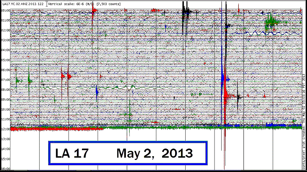
This Joint is Jumpin’! (We Don’t Mean the Community Meeting)
Quake Watch has readable seismo charts for Lake FUBAR. So we decided to check this morning.
Look at the new one at LA17!
http://enenews.com/video-giant-sinkholes-volume-tripled-october-15-acres-total-settlement-area-almost-40-acres
( Tripled in size since October and going to grow for another year or two - or are they just hoping it's going to stop somehow ? )
At 7:00 inGary Hecox, CB&I hydrogeologist: Right now the volume of water in the sinkhole is about 3 times bigger than it was last October. […]The current area of the sinkhole is 15.1 acres. That is an increase of 2.7 acres from March.The total settlement area according to Miller Engineering report is now 37.5 acres. That was also an increase.The volume of the sinkhole increased about 300,000 or 400,000 cubic yards in March.
http://enenews.com/cbs-news-giant-louisiana-sinkhole-could-continue-grow-years-company-official-video
Mark Strassmann, CBS Reporter: But [Bruce Martin, Texas Brine Company, LLC vice president of operation] Martin also admits the sinkhole could continue to grow for another year or two.