Hurricane Harvey....
Afternoon / Evening Tweets....
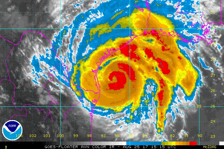
As I thought it might , just hit Cat 4 - as it approaches landfall !
Latest Hurricane Harvey updates: http://nbcnews.to/Harvey

Harvey continues to intensify according to @NHC_Atlantic and is now a category 4 #hurricane with maximum sustained winds of 130 mph.

Catastrophic flooding expected in Texas from #Harvey due to extremely heavy rainfall & life-threatening storm surge http://hurricanes.gov


Morning tweets....
So it seems I'm in for 8"-10" of rain this afternoon as a result of Hurricane Harvey... in Austin! 200 miles inland!

4am CDT Key Messages for Hurricane #Harvey. Preparations along the Texas coast should be rushed to completion.

Tropical Storm conditions are likely to reach the coast by this afternoon. More graphical products available here: http://www.nhc.noaa.gov/graphics_at4.shtml …

#HurricaneHarvey has strengthened to a CAT 2 storm. It's expected to make landfall north of Corpus. Watch TWC for live Tropical Coverage.

Looks like an eye is beginning to clear out of the center of #HurricaneHarvey

Hurricane #Harvey Advisory 19A: Dangerous Hurricane Harvey Strengthening. Winds Reach 105 Mph. http://go.usa.gov/W3H
HURRICANE HARVEY UPDATE
-New mandatory evacuations for 3 Texas counties
-Potential surge rises from 10 ft to 12 ft
http://abcn.ws/2vllqMo

Hurricane #Harvey:
Latest (00Z) GFS still shows tremendously heavy rainfall for Texas and Louisiana, maxing out the scale.
>40" possible.
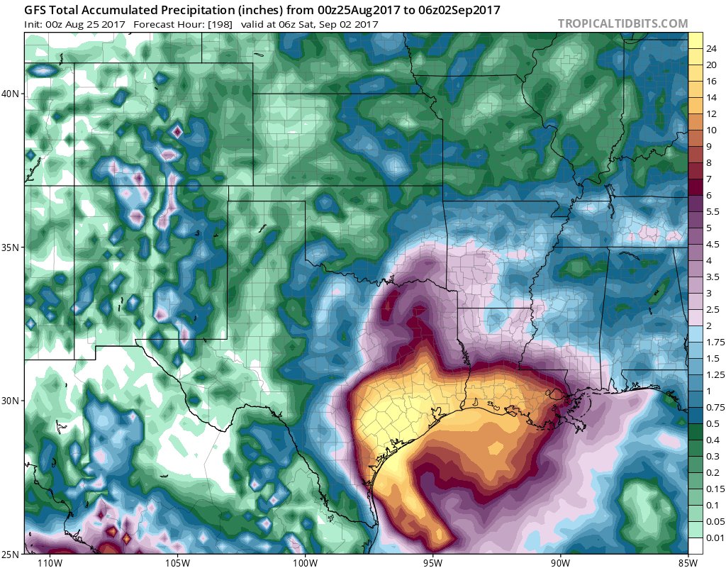
NWS WPC rainfall update from Hurricane #Harvey continues to absolutely inundate Texas & Louisiana. Huge area 14-24"
17 Trillion TX, 6T LA

#Harvey flooding impacts to continue into next week with isolated 30+ inches possible .Turn Around Don’t Drown. http://tadd.weather.gov

The eye of #Harvey is now visible on the Brownsville Radar. NHC will begin issuing hourly position updates at 11:00pm CDT.

As of 10 PM CDT, Hurricane #Harvey still expected to make landfall Fri night/early Sat. Expected to stall near/just inland on mid TX coast.


The latest 7-day WPC QPF forecast. 25+ inches of rain expected with #HurricaneHarvey . Stay safe!!

Rapidly deteriorating conditions from #Harvey will begin along TX coast during the day Friday. Preparations should be rushed to completion

Hurricane expert Dr. Rick Knabb has an important message about #Harvey
http://bit.ly/2xgIihJ

No comments:
Post a Comment