New items on the sinkhole - however , first a recent post as a recap - lots of photos and information set forth at the prior post , the recent video noted below......
http://fredw-catharsisours.blogspot.com/2013/03/march-26-2013-louisiana-sinkhole-keeps.html

4/1 updates - April Fools believe what they are told in La......
Now for new items for 3/31.......... A great article from Freedomrox and also a detailed comment . To understand what's happening , understand when the sinkhole situation is discussed generally , most discussion focuses on what might be called OXY # 3 ( Comedy of Error Article discusses OXY # 3 for example . ) However , there are also issues with OXY# 1 ( the detailed comment focuses on that , as well as OXY # 3 . )
 http://lasinkhole.wordpress.com/2013/03/31/what-is-going-on/
http://fredw-catharsisours.blogspot.com/2013/03/march-26-2013-louisiana-sinkhole-keeps.html
March 26 - 29 , 2013 - Louisiana Sinkhole keeps growing as another 25 trees fall into Lake Fubar .... Strange things going on near the sinkhole......
New Fly Over Shorties, New Photos
15
LINK - http://youtu.be/YQKtVwhUlhY
LINK – http://youtu.be/LRvIwcU0ZAg < 12 seconds! Don’t blink!
NEW PHOTOS -
no wonder the parish put these up secretly
4/1 updates - April Fools believe what they are told in La......
Late Monday News – New Photos from DNR
Conservation Dept. a new advisory on the parish blog today -
The Office of Conservation, in consultation with Assumption ParishIncident Command, is advising the public that the Oxy 3/sinkhole monitoring alert status has been raised to Code 2 – requiring all work directly in and over the sinkhole to cease until further notice. . . (more)
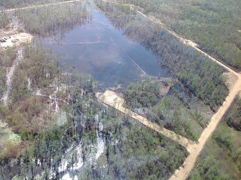
DNR inspection photos from Mar. 29. Photos - (‘as is’ art is from DNR not us)
Notice the oily patches . . . it seems to be what they are pointing out.
Weird Seismic Activity Last Night, 11 p.m.
Most the helicorders show an anomaly at the same time. 11p.m. March 31 (Easter) something happened at 2300 hours, 11 p.m. -
select “ 03/31/2013 (12) ” from the helicorder page to see the timeframe…
see lower left corner of these charts -
see lower left corner of these charts -
- LA10 EHZ YC 01
- LA10 EHZ YC 02
- LA10 HHZ YC 03 had just a plunk
- LA11
- LA12
- LA13 had just a plunk
- LA14
LA15 YIKES!!!
- LA16 had just a plunk
Now for new items for 3/31.......... A great article from Freedomrox and also a detailed comment . To understand what's happening , understand when the sinkhole situation is discussed generally , most discussion focuses on what might be called OXY # 3 ( Comedy of Error Article discusses OXY # 3 for example . ) However , there are also issues with OXY# 1 ( the detailed comment focuses on that , as well as OXY # 3 . )
http://freedomrox.wordpress.com/2013/03/31/louisiana-sinkhole-comedy-of-errors-or-intentional-gamble/
LOUISIANA SINKHOLE: COMEDY OF ERRORS OR INTENTIONAL GAMBLE?

I have avoided for a while giving my opinion and the opinion of many others, the light of day concerning how this geological nightmare in Assumption Parish, Louisiana, also known as the “Great Louisiana Sinkhole”, came into being on August 3, 2012..
I can no longer put this off as so many have sent emails asking for my humble opinion and compilation of the events that led up to the present situation. Please take into account this is not just my opinion alone, and that there is a reputable geologist, hydrologist, seismologist, and a salt rock mechanic, (geologist specializing in salt rock formations), that comprise the team that makes this blog possible. All are volunteers, and they are all greatly appreciated. Most are still engaged in their respective fields, and therefore cannot be named at this juncture, for fear of retaliation.
With that firmly stated, and acknowledged, then on with the explanation as we see it.
First we have Hooker Oil Well #1 that was drilled to a depth of 6,200 ft., which is why it was later named 6200 RA SUA , (HookerOilWell1 History). The well was first drilled and completed in 1986 down to the depleted formation shown in the 2007 3-D survey. It was drilled 338 ft. directionally in an southeastern direction for a Bottom Hole Location offset..
It changed hands a few times until Energy Self Service Oils, Baton Rouge, La. took it over in 2006 for Natural Gas, then sometime between then and Feb. 2009, (likely earlier, since its shown depleted in 2007 3D survey by Golden Gate), just up and walked off.
Orphaned without a word to anyone. The state had to come in and P&A the well themselves in 5/12/2010. This shows the actual effectiveness of the Dept. of Conservation, as it took them three (3) years, to figure out this well was orphaned and only because deer hunter’s complained about the oil leaking from the wellhead and rusting tanks left behind. This was an open well, and right next door to the Oxy #3 cavern and at the same depths. The depletion of this formation right next door to Oxy 3 and the salt dome may have had a role to play in all of this due to its proximity just underneath the Oxy #3 Cavern, and I intend to prove just how.
ERRORS: (Part I)
OIL WELL VS. SALT CAVERN EQUALS DISTRESSED SHALE SHEATH
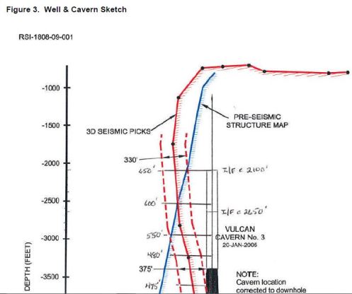
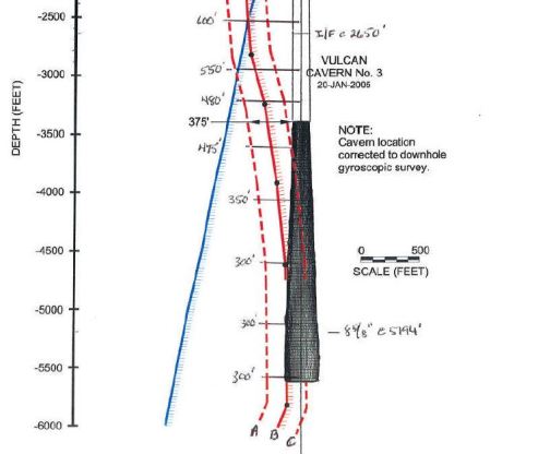
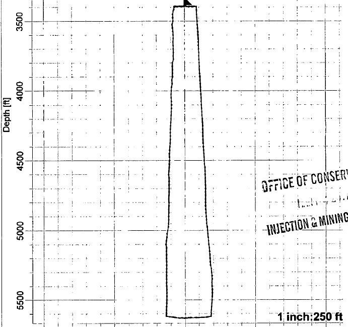
Recall that the Oxy #3 cavern was at a depth of 5,923 ft. deep, and Hooker Oil Well #1 (later changed to SUA 6200), was drilled to 6200 ft. just 980 ft. (surface wellhead) from Oxy #3 (surface wellhead). The top of hydrocarbon sand formation was at a vertical top of approximately 4235 ft., and a bottom depth of approximately 6500 ft. dropping even lower along the gradient of the salt wall, according to the 2007 3D survey, so now it is time to do some quick math.
At surface 980 ft. between wellheads, and taking into account half the volume of the bottom of Oxy 3, which was 300 ft., then we are left with 150 ft (+/- 30 ft.) jutting to the west side from center of bore. Then taking into account an ‘M’ sands formation of approximately 900-1000 ft. (squared) pay extrapolated from nearly 20 years of production before considered depleted, due to the drive force reaching static pressure, (usually a water drive, but sometimes other drives exist, likely methane gas, and does not mean empty, just no longer able to recover hydrocarbons), with an offset casing of 338 ft. towards the Shale Sheath, leaving 750 ft. (horizontal) pressuring the shale sheath eastward with the formation top at 4235 ft. and a sloping bottom formation depth of 6500 ft. (vertical) leaves us with only 50-80 ft. (again +/- 30 ft.) of Shale Sheath separating the Oxy #3 cavern and the bottom 1016 ft. (vertical) of said Cavern 3 being pressured by the oil formation against the Shale Sheath, as shown by the straight line deformation of the SONAR survey of Oxy #3, with pressures slowly falling over the years of the oilwell’s useful lifespan, while at the same time Texas Brine is mining salt from inside the Salt Dome’s edge, therefore exposing more of Cavern 3 to the shale sheath over it’s useful lifetime.

Now if that doesn’t clarify things for you, then it sure should have left the reader completely baffled. Essentially, a very thin shale sheath was separating the bottom 1000 ft. of the Cavern from the pressuring oil formation abutting against the sheath. This pressuring could have been a good thing until the pressures decreased and not exerting the same amount of force as it previously did before being produced. Any Geologist worth his salt, (pun intended), could see the straight line deformation of the Sonar scans of Occidental Geismar Brine Well #3, and realize it was pressing against a solid surface and not an elastic one such as salt rock which is never in a straight line.
ERRORS PLUS A GAMBLE: (Part II)
The Mill Out:
It seems ever more self-evident that Texas Brine knew what was happening with Cavern 3, and made plans in 2010 to abandon Cavern # 3 in favor of milling out an upper cavern starting at 2350 ft. Remember the top of Cavern 3 was at 3400 ft. so this left Texas Brine with nearly 900 ft. of salt above Cavern 3, (once they cemented the top of this cavern), and 1400 ft. above to stay safely below the caprock, then, dear reader, please realize how much salt could have been mined from such a space for years to come, and a source of income for Texas Brine and the Owner, Occidental Chemical Corp. if they had pulled this gamble off.
Unfortunately, at best, only 300 ft. of salt existed at 2350 ft.from the outside of the dome, and at worst only 100 ft. of salt separated the dome from the outside shale, and a normal mill out pressure is initially approximately 1500 psi at depth or 0.8 psi per foot of depth, (per Regulations) which would create a cavity of approximately 100-200 ft of open space around the wellbore casing using freshwater. It is my contention, and the opinions of others far more experienced than I am, that the salt was breached into shale and the overburden of the salt overhang slammed down and thereby set off a nearby fault line in the shale, which was truly the beginning of this entire disaster. The shale sheath protecting Cavern 3 fractured as a result of this Mill Out, and cavern pressures were immediately noted to be dropping.

Suspecting this was the case, then Texas Brine commissioned Baker-Hughes to come in and run a Vertical Seismic Profile, (VSP), on September 25, 2010, and permitted by LDNR and Conservation, to map the edge of salt after the fact, instead of doing so before the fatal Mill Out of May, 2010.
An engineering blunder that is costing them unto this day, yet Occidental is still the Owner of the Cavern and of the land and mineral rights, and suffers none of the liabilty publicly. One wonders what the agreement is between the two companies that allows this situation to occur?
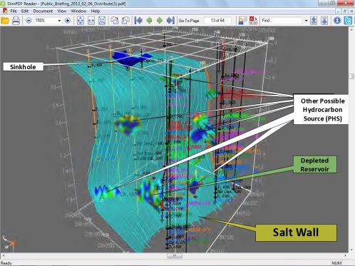
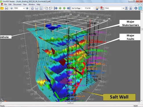
As a reminder, here are the results of that VSP.


It has been postulated by Mr. Gary Hecox, and Mr. Will Pettitt, that eight oil and gas bearing formations are pinched up against the edge of the dome and supplying all of the methane gas, oil, and produced waters via the ‘Disturbed Rock Zone’. It is a flimsy premise at first glance considering the eighth producing formation sand level is over 14,000 ft. deep, and surely natural formation waters alone would not provide a strong enough ‘drive’ to provide the ‘push’ that the heavy hydrocarbons would need to force their way to the surface if not fractured or drilled. Upon further investigation though, maybe they know something we do not. Possibly a very BIG something.
Such as the fact that there are no obstructions between the sand formations at depth and the E&P Injection Wells within close proximity to the edge of the Napoleonville salt dome. E&P, stands for Exploration and Production Wastes, such as drill cuttings, brine wastes, benzene, toulene, etc. and such, within production water wastes from oilfields. For more information on E&P Wastes, please consult:http://www.epa.gov/osw/nonhaz/industrial/special/oil/oil-gas.pdf
The closest is the old Hallar Enterprises Inc. Disposal Site on Hwy. 70, Pierre Part, La., which is less than a mile away as the crow flies and formerly injected wastes to a sand formation at just over 12,000 ft, deep into a depleted oil well, and fractured shale, where oil sands may easily carry injected produced waters in a south easterly direction. This well has been P&A’d, (Plugged and Abandoned), and the building torn down, yet the wastes still remain somewhere….
Next are two wells owned by FAS Environmental Services LLC in Pierre Part, 1081 Hwy 70 Well Serial Numbers 156044, and 973168. One such Injection well Serial # 973168 injected1,156,970 Barrels in 2011 alone, download the report below:
and
That is 48,592,740 million gallons in just 2011 alone injected at a depth of 3700 – 3965 ft. bearing sands. It makes one wonder just what kind of oversight is in place around these Salt Domes to allow such polluted wastes to be slurried into sand streams, and what by-products are generated at depths that could easily be the ‘push waters’, (produced waters), that are possibly the actual drives behind the waters that are forcing hydrocarbons into the MRAA at the sinkhole in Bayou Corne, as well as forcing the methane gas deposits into the aquifer as well.
As an Aside; I have still not received any answers from Texas Brine, LLC, as to the disposition of their NORM/TENORM deposits, and LDNR refuses my calls. FOIA anyone?
Where are the regulations, statutes, codes, and laws to guard against such irresponsibility? Not only in regards to Deep E&P Waste Water Injection Wells, but to protect the public health and welfare from insane business practices that do not consider the lives, health, or environment in their business models?
This is a wide spread concern and not just in Louisiana, but this State’s Department of Conservation is a Joke! It’s Department of Environmental Quality has completely DEPARTED, and the Department of Natural Resources seems to be onboard with the Louisiana Independent Oil and Gas Association!
Just as Scott Angelle, the former head of LDNR jumped ship within days of the Sinkhole Disaster, and moved away from the area, to pursue his own interests in the (LOL) “Public Service Commission”, to side-step and avoid the crimes he was responsible for; so too it seems that James Welsh, the ‘Maestro’ behind all of this absolutely horrific breakdown of regulations and rules regarding all forms of Injection Wastes since 1978, and even more lax over-sight of any Salt Dome Caverns, and Deep Well EP Wastewater Injection Wells that dot most of the State…just skates on away, while the collateral damage of wasted lives, cancer-ridden victims, taxpayers, and tourists, suffer for these ‘Officials’ greed and personal aggrandizement, as well as hubris…that,in and of itself, to me…. is the most reprehensible of crimes.
Hopefully, I have expressed the people that proffer their technical expertise to me free of charge, as well as their opinions and professional acumen appropriately, and apologize to these good people for my emotional statements towards the end of this article, yet I cannot regret my words. It is time for a change. This time for the better. It is OUR WORLD, not the politician’s, lobbyist’s, special interests, nor the playground of big corporations. It is all of ours, and it’s time we take back what is ours.
As a parting shot, please take a look at my very horrible graphic, (gimme a break, I did it in Paint), to give a hint as to what we suspect is truly happening beneath the earth on the Western face of the Salt Dome. After intensive study, none of us could find a fault block area that would prevent this scenario from actually taking place, but since none of us can actually stick our heads down 12,000 ft., then of course it is all subjective. (Again forgive the childish quality of the hand painted graphic as it is only for visualization purposes of a probable scenario)
LEGEND:
Red=Oil Formations and flows
Purple=Produced Waters
Green= Chemical mixes
Yellow=Methane gas
Light blue=natural water drives
Orange=Oil Sands carrying lower formation waters, and gases
Blue=Surface Water
Black Spots= fractured sedimentary materials
(Click to enlarge)
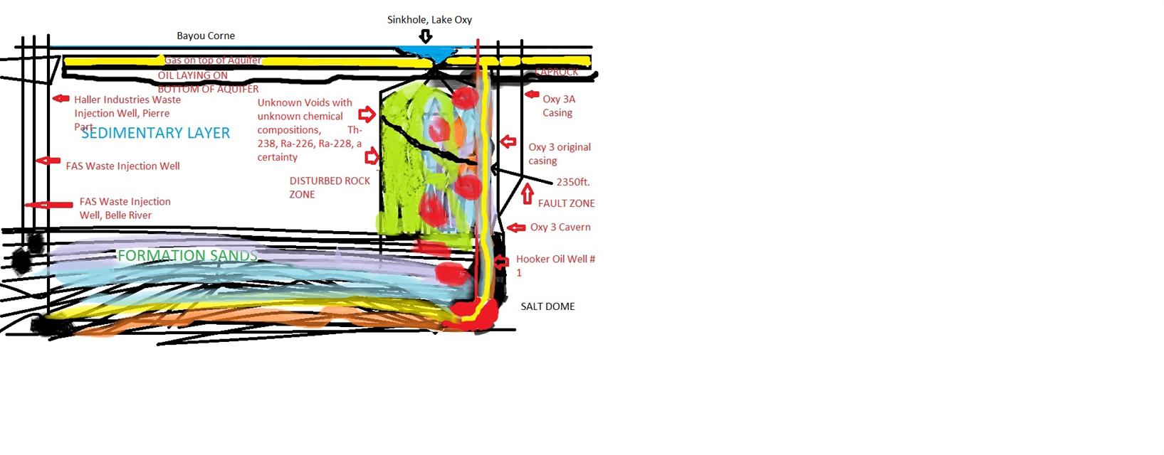
Reader: An Idea About What is Going On Down Below
Here’s what they don’t want you to know. Oxy 1 is being bled off twice a day due to over-pressures. Over last couple of days they are preparing to or already have installed a Blow Out Preventer, (BOP), courtesy of Halliburton, of course. Now you might ask why in hell would they need a BOP on a brine well? Damn good question.
Also, there is a wireline that is being run between Oxy 1 and Oxy 3A, presumably a seismic net to seek out a fracture caused as a result of their Barge/Air Gun experiment, which is why Pad 3 caved on both sides, and the access ramp fell in.
Also, there is a wireline that is being run between Oxy 1 and Oxy 3A, presumably a seismic net to seek out a fracture caused as a result of their Barge/Air Gun experiment, which is why Pad 3 caved on both sides, and the access ramp fell in.
Now, what is all means? I dunno…but looking at the fluidic communications taking place at around 200 ft. means the liquids in the aquifer are sloshing around at a good rate being so perturbed by the inrush of methane, which then sets the earth to rocking until it sets the small fault at about 1000 ft. down to 5500 ft. to vibrating like a tuning fork, sparking even more micro-quakes, which in turns shakes the ‘Disturbed Rock Column’ and changes the geology of the underlying sedimentary layers and hence the size, shape, and volume of the voids. This whole system is acting like a fractionating plant, without the benefit of the stainless steel filtering tower, of course.
As I have stated before, and will again, this washing machine effect is creating chemical compositions never before seen upon earth, as well as shaking loose the uranium deposits, speeding up the natural processes that createThorium, Radium-226, and Ra-228. At some point, this does come into contact with the environment, considering we haven’t a clue where all the venting fractures lead…