LOUISIANA SINKHOLE AND PROOF LDNR AND TEXAS BRINE KNEW OXY 3 COULD FAIL IN 2010
2
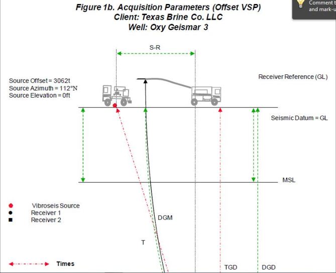


Baker Atlas conducted a Checkshot Survey and an Offset VSP Survey for Texas Brine Company Ltd. in the well Oxy Geismar 3, located in the Grand Bayou field, Assumption Parish, Louisiana. The objectives of the surveys were to:
Measure time-depth information
Image the salt flank
At the time of the survey, the well had been flushed to create a cavern below 3400ft.
They knew! And they knew about the rad waste too!
http://lasinkhole.wordpress.com/2013/01/20/barfs-sun-news/
Sinkhole Barfs, New Fly Over + Sunday News
The Advocate has a photo of the work site with cracks – (hard to see the cracks)
“The cracks, which are 1 inch wide and 14 inches deep, extend from the north side of the pad around to the southwest side of the pad, Boudreaux said.”
Sinkhole seismic event studied
By Robert Stewart -
Scientists believe the restless, 8.5-acre[sic] sinkhole in Assumption Parish swampland is undergoing a “growth event” after they noticed an upswing in seismic activity in the past few days within a brine-mining cavern carved into the massive Napoleonville Dome, parish officials said Saturday.
Officials first began noticing an increase in seismic activity about two weeks ago, said John Boudreaux, director of the Assumption Parish Office of Homeland Security and Emergency Preparedness.
Scientists reported that more than 80 seismic events were monitored two days ago, Boudreaux said.
“There was a tremendous amount of activity over the past couple of days,” Boudreaux said.
The sinkhole then “burped” up crude oil, debris and hydrocarbon to its surface around 10 a.m. Saturday . . . .
New Fly Over!

LINK - http://youtu.be/Oz78aC-R7Sc
They must’ve used the Concord! It is a big 18 seconds long! Don’t fall asleep!
Thanks to parish officials for allowing embed feature on videos again!
http://www.houmatoday.com/article/20130119/ARTICLES/130119602?p=all&tc=pgall
Sinkhole to be seen in 3-D
Area residents have been evacuated for more than 5 months.
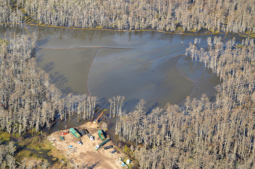
An aerial view of the sinkhole in Assumption Parish taken earlier this week. Flooding from heavy rains mix the swamp with the 9-acre hole.
Published: Saturday, January 19, 2013 at 6:01 a.m.
Last Modified: Saturday, January 19, 2013 at 12:42 a.m.
Scientists are starting to map out a three-dimensional look of the ground below the Assumption Parish sinkhole as nearby residents approach the sixth month of being evacuated.
The sinkhole was discovered on Aug. 3, prompting an evacuation of about 150 homes in the nearby Bayou Corne community.
In the time since, state and local officials have been able to determine the cause of the now 9-acre hole but have not been confident enough with the situation to lift the evacuation order.
“There are many things that are still a mystery,” said John Boudreaux, Assumption Parish Office of Emergency Preparedness director.
The hole is about 660 feet wide and has grown largely because of sloughing off on the edges, Boudreaux said.
“The evacuation order is still necessary because there are three benchmarks we are still looking for answers to,” Boudreaux said.
Last year, scientists determined the hole was caused when a subterranean cavern owned by Texas Brine LLC collapsed.
The cavern sits thousands of feet below the surface in the Napoleonville Salt Dome. Salt domes are naturally occurring deposits of salt. Private companies commonly carve out deposits in these domes to store volatile gases or waste.
Texas Brine was using the failed cavern to extract brine, which is used in various industrial and oilfield applications.
Boudreaux said officials want to determine how much of the earth between the sinkhole and failed cavern has settled.
“There is the possibility that there are other void spaces in the ground,” Boudreaux said.
These void spaces could eventually lead to the sinkhole growing or another hole as the failed cavern fills completely in.
“We don't know for sure yet, that is the issue,” Boudreaux said.
Following a brief conflict over what solution would work best, the state Department of Natural Resource and Texas Brine agreed that 3-D imaging of the subsurface would give researchers an exact picture of how the earth might shift in the future, said DNR spokesman Patrick Courreges.
Courreges said the goal is to have the imaging complete by April.
Boudreaux said there also needs to be an effort to get the gasses trapped below the community down to safe levels.
Texas Brine and the Department of Natural Resources have underground wells venting off the gas.
Boudreaux said they've vented about 5 percent of the gas estimated to have accumulated near the surface. Nobody knows how much gas is below the area, he said.
Texas Brine is in the process of drilling more vent wells, Courreges said.
Texas Brine has been fined twice for not following a state directive to install gas monitors in local homes, Courreges said. The fines total $250,000 and were also assessed for failing to property contain oil and gas in the sinkhole.
The first of the in-home monitors were installed Thursday while the rest should go in within a few days, Boudreaux said.
Another concern is the stability of the rest of the salt dome. Boudreaux noted there are other caverns inside the dome and some house oil and gas.
“The concern is this cavern would have a domino effect on other caverns because this one is failing,” Boudreaux said. “It could cause a bigger problem.”
Boudreaux said there isn't a time frame for lifting the evacuation order because there are still these unknowns.
“There is no book to tell us what will happen over time,” Boudreaux said.
Parish Police Jury President Martin Triche said the residents of about half of the 150 homes under evacuation have heeded the order.
“I've always said the pace is going too slow,” Triche said. “My impression is that if Texas Brine had been more aggressive early along, we could have had this settled by now.”
Aside from the residents' safety there is also concerns about property values plummeting, Triche said. He said he asked Texas Brine to consider offering buyouts to those who don't feel the area is fit to live in anymore.
“Many of the residents don't want to move away,” Triche said. “We hope to restore things back to their normal environment.”
It's unclear how long that might take, but in the meantime, Boudreaux said there are two public meetings scheduled in the coming weeks. The first will take place on Jan. 30 and feature scientists from Texas Brine. The next will be on Feb. 6 and feature state scientists and scientists from the Shaw Group.
Both meetings are scheduled for 6 p.m. at the Assumption Parish Community Center.
Sat. Evening Post – More S- – - hittin’ the fan at the sinkhole. Workers Evacuated.
We don’t usually do multi-updates for the same day but today, Jan. 19. everything is going south at Lake FUBAR.
LA10

Since everything is goin’ nuts with the seismic monitors maybe check the sidebar for additional info on them. →
Also the map of the monitor locations is here. And here’s a little info Walter Coin sent before describing the heliocorder locations:
EHE and EHN and EHZ are surface
LA10 EHE GS 10 : South of Highway 70, Bella Rosa, Louisiana, surface
LA10 EHN GS 10 : South of Highway 70, Bella Rosa, Louisiana, surface
LA10 EHZ GS 10 : South of Highway 70, Bella Rosa, Louisiana, surface
LA10 EHE GS 10 : South of Highway 70, Bella Rosa, Louisiana, surface
LA10 EHN GS 10 : South of Highway 70, Bella Rosa, Louisiana, surface
LA10 EHZ GS 10 : South of Highway 70, Bella Rosa, Louisiana, surface
EH1 and EH2 and EHZ are borehole
LA10 EH1 GS 11 : South of Highway 70, Bella Rosa, Louisiana, borehole
LA10 EH2 GS 11 : South of Highway 70, Bella Rosa, Louisiana, borehole
LA10 EHZ GS 11 : South of Highway 70, Bella Rosa, Louisiana, borehole
LA10 EH1 GS 11 : South of Highway 70, Bella Rosa, Louisiana, borehole
LA10 EH2 GS 11 : South of Highway 70, Bella Rosa, Louisiana, borehole
LA10 EHZ GS 11 : South of Highway 70, Bella Rosa, Louisiana, borehole
Inspection Report from DNR is out for Jan. 17.
Texas Brine doesn’t think anything noteworthy happened today. No update from them since Jan. 12th.
http://assumptionla.wordpress.com/2013/01/19/330-p-m-update-from-dnr/
The Office of Conservation, in consultation with Assumption Parish Incident Command, is advising that the Texas Brine facility sinkhole appears to be undergoing a growth event, indicated by a recent upswing in measured seismic activity that began to decrease about the time of this morning’s release of debris and crude oil to the top of the sinkhole, as well as the appearance of cracks on the surface of the Oxy 3 well pad, located directly above Texas Brine’s failed cavern and on the eastern side of the sinkhole.
Monitoring of seismic activity and direct field observations from ground level and overflights are part of the ongoing response to determine the potential extent of this latest growth event – one of several observed since the formation of the sinkhole. Observations indicate that the current growth event is centered on the east side of the sinkhole – possibly related to shifting of salt and material within the cavern collapse zone. After a period of heightened activity, the number and strength of sharp seismic events dropped markedly following the release of debris and hydrocarbons from the sinkhole – though impacts at the surface on the eastern side of the sinkhole will continue to be monitored closely.
Following the appearance of the well pad surface cracks on the southwestern corner of the Oxy 3 well pad, the Office of Conservation advised that personnel and equipment should be removed from the site to ensure safety while observation and analysis of the growth event are ongoing.Though the exact timing and extent of episodic growth events cannot be predicted, the Office of Conservation and its consultants had identified the Oxy 3 well pad as being within the area of potential sinkhole growth, and has maintained constant monitoring of subsurface conditions and activity for signs of instability in order to act quickly to protect the safety of the public and workers on site.
and....
There has been increased seismic activity near the cavern this morning as well as developments of cracks on Oxy 3 pad. At approximately 10:00 this morning, another burp occurred in the sinkhole. The State Police helicopter has arrived to provide aerial viewing. Additional information will be posted as it becomes available.
Lake Fubar waking up ?
Sinkhole Area (wide area) Residents – Maybe Take OFF This Weekend
Perhaps it is a good idea to pack up the car and go camping, visit relatives or see sites out of state.
Lake FUBAR is rumbling and it doesn’t look good! We are not NASA here … but it may be time for a weekend escape simply because there are few roads out of the area should things get radically worse in the next few hours.
That is just this blog’s opinion. Don’t mean to create a scare … but a little trip may be well worth the bother right now.
If we didn’t speak up and anything bad happened we’d feel so bad.
GO, GO, GO!
Saturday News – HELLZAPOPPIN at Lake FUBAR
PARISH UPDATE:
There has been increased seismic activity near the cavern this morning as well as developments of cracks on Oxy 3 pad. At approximately 10:00 this morning, another burp occurred in the sinkhole. The State Police helicopter has arrived to provide aerial viewing. Additional information will be posted as it becomes available.
Helicorders more than drunk -
LA03 -

LA10

ENE-News – *Just In* Officials: Increased seismic activity under giant sinkhole — Cracks developing on pad nearby — Another ‘burp’ this morning — State Police helicopter on-scene
Adding .. . . stay tuned!
Note: Lots of videos from many sources on increased bubbling spots around Bayou Corne in Friday’s News.
The Advocate – Rain reveals gas bubbles
BAYOU CORNE — High water from recent heavy rains revealed small sources of natural gas venting in the Bayou Corne community, a swampland settlement that has been evacuated for more than five months since the formation nearby of a large sinkhole, residents and officials said. . . .
“John Boudreaux, parish Office of Homeland Security and Emergency Preparedness director, said Friday the bubble sites have been tested, but they were not emitting enough gas to be detected by the instruments.”
ENE-News comments on the story.
HuffPo notices Governor Jindal Continues to Ignore Growing Sinkhole
Louisiana Sinkhole Operation: Bottom Kill and Top Fill
A Vertical Seismic Profile (VSP) is being performed now at the Louisiana Sinkhole in an effort to locate the source of the hydrocarbons and oil deep below the earth that was tapped into by Texas Brine's Oxy 3 brine cavern which explosively failed on August 3rd, 2012, and created the slough in, known to local residents as the 'Stinkhole'. This Vertical Seismic Profile will be explained in the next article.
Friday News
Helicorders are doing all sorts of strange things today.
MANY BUBBLING PUDDLE VIDEOS TODAY
Video taken by Mike Schaff:
LINK – http://youtu.be/Wkot_kgoc4Q
ENE-News - Watch: Methane bubbling up in residents yard near giant sinkhole — “I can actually hear the bubbling” (VIDEO)
LINK – http://youtu.be/ibXjo387ECo
A new DNR Inspection Report is out.
LINK – http://youtu.be/Of61jljTYWk
LINK – http://youtu.be/ekFBPmOzRFE
New Fly Over Video! New PHOTOS!
LINK – http://youtu.be/FKiPb3h4q00
NEW PHOTOS!
With the new look at the scene here is a labeled photo for purposes of discussion:

< CLICK ON IMAGE FOR FULL SIZE
Another Hole Can Open at Sinkhole (??)
JANUARY 17, 2013
4
ENE-News – Video: Experts said there’s an extreme amount of gas in aquifer near giant sinkhole — Another hole can open up if there’s a weak spot according to officials
Community advocate John Achee Jr.: A lot of experts have told me there’s an extreme amount of natural gas in the Mississippi Alluvial Aquifer.
DNR themselves have said that it’s possible for another sinkhole to happen if the natural gas in the aquifer finds another weak spot, another sinkhole can happen.
DNR Inspection Report for the 15th is Out
Not too much changed -
Here’s what all the comments were about yesterday (from error-prone removed post) -

and....
On US Spent Nuclear Fuel & Salt Domes
JANUARY 16, 2013
We were looking at this new addition to the Salt Dome documents page – Texas Salt Domes–Aspects Affecting Disposal of Toxic-Chemical Waste in Solution-Mined Caverns and we did a simple search in the document for the word “radiation” and found this:
(p.57)
Creep laws are one kind of the many constitutive laws that model the ratedependent deform at i on of materi a 1 s. Creep 1 aws are app 1 i ed to the des i gn of underground storage caverns, radioactive waste repositories, and to salt mines
where the combination of stress, temperature, and time gives rise to significant time-dependent deformation.
(p.86)
Results of the operation of Project Salt Vault: a demonstration of disposal of high-level radioactive solids in salt: III Symposium on Salt, v. 10, p. 455-462.
(p.88)
1978, An investigation of the utility of Gulf Coast salt domes for the storage or disposal of radioactive wastes,
Volume I: Louisiana State University, Institute for Environmental Studies, Contract Report EW-78-C-05-5941/53, 390 p.
(p. 179)
Fenix and Scisson, Inc., 1976a, Review of applicable technology–solution mining of caverns in salt domes to serve as repositories for radioactive wastes: Prepared for U.S. Energy ResearCh and Development Administration, Office of Nuclear Waste Isolation, Oak Ridge, Tennessee, Y/OWI/SUB-76/92880, 122 p.
(p. 283)
1976, Review of applicable technology–solution mining of caverns in salt domes to serve as repositories for radioactive wastes: Prepared for U.S. Energy Research and Development Administration, Office of Nuclear Waste Isolation, Oak Ridge, Tennessee, Contract No. Y /OWI/SUB-76/92880, 122 p.
(p. 154)
Salt Dome Name Mineral Status of Production Reporting Org.or
Mining Method Name of Co.
MARKHM BRINE ACTIVE BRINE WELLS Texas Brine
(p. 321)
PIERCE JUNCTION “ “
SPINDLETOP “ “
AND -
We came across this interesting paper on Project Salt Vault -
The primary objective of Project Salt Vault was to demonstrate the safety and feasibility of handling and storing high level nuclear waste (HLW) solids from power reactors in salt formations. The engineering and scientific objectives were to:
· Demonstrate waste-handling equipment and techniques required to handle packages containing HLW solids from the point of production to the disposal location.
· Determine the stability of salt formations under the combined effects of heat and radiation (approximately 4,000,000 curies of radioactive material, yielding up to 109 rads).
· Collect information on creep and plastic flow of salt needed for the design of an actual disposal facility.
· Monitor the site for radiolytic chemical reactions, if such should occur.
We don’t know if HIGH LEVEL nuke waste is in Bayou Corne but we don’t know that’s it’s NOT there!
and....
Revisiting the Advocate Exposè on the Napoleonville Salt Dome
JANUARY 16, 2013
Reblogged from flying cuttlefish picayune:
This is hidden on the HOME section of The Advocate -
Dome issues kept quiet
David J. Mitchell
August 13, 2012
Louisiana Department of Natural Resources and Texas Brine Co. officials knew at least since January 2011 that one of the company’s salt dome caverns may have developed problems now suspected of possibly causing a large sinkhole and unexplained natural gas venting in northern Assumption Parish swamps.
Read more… 64 more words
and.....
HIGH PRESSURE at WELL #3 – The BUTANE Cavern
High Pressure at Well #3
Some aspects of the condition of Well #3 trouble reader, Tony Gentile. He says the DNR Inspection Report for Jan. 14th shows very high pressure. He says:
That’s a hell of a lot of pressure. That’s 614 pounds of force (pressure) on every square inch. A ten square inch area would have the equivelant of 6140 pounds pushing on it. That’s an incredible amount of energy.
NOTE: Well #1 is the sinkhole damaged cavern and Well #3 is the butane cavern
The last update on the removal of butane (to a nearby cavern & selling off) by Crosstex. It contains 39.000 BARRELS of butane.
Freedomrox already issued a warning about that HIGH PRESSURE.
Texas Brine – WHAT ARE YOU DOING???
.
shortlink to this page - http://wp.me/p2GNDM-1vq
and.....
Seismic Recorders Turned Off & Wed. News
Nothing for Jan. 16 on the helicorders. Maybe they are hooking something up. But they went out early in the day yesterday.
ANOTHER BARF??
The DNR inspection report for yesterday (1-15) reveals construction at well 3 … maybe they have to repair the road from flooding. No idea.
And DEBRIS at Oxy-Geismar Water Well #3 (grey pump station on right just before the sinkhole)

NOTE: Well #1 is the sinkhole damaged cavern and Well #3 is the butane cavern
Just ADDED to the Salt Dome page – Texas Salt Domes–Aspects AffectingDisposal of Toxic-Chemical Waste in Solution-Mined Caverns
.
shortlink to this page is - http://wp.me/p2GNDM-1v4
and.....
This may be unrelated to the sinkhole – 40 children hospitalized after gas leak at school in Nashville
Not the sinkhole either, but Walter Coin sent this in – -
LINK – http://youtu.be/6zGsujlR4fY
and.....
A Warning to Texas Brine from Freedomrox
Beware People. The Methane pressures are spiking due to the Thumper, and the Shut In wells.
One has popped a pressure gauge and it’s not looking very good. If the pressures keep rising, then the Residents are looking forward to another ‘Big Burp’. Whoever is doing the VSP needs to pause. Otherwise, the ‘sweet smell’ of success could easily turn to back pressures that will have a negative effect on the workers and the residents.
This is a warning!
Take Heed!
Please!
In other words, until you can vent properly, quit grabbing the Tiger by the Tail! Don’t poke a stick at a Water Moccasin! Stop throwing fish at the Gator!
and he says to Texas Brine -
You honestly don’t know what you are messing with… I know you have a job, but it isn’t worth exposure to toxic chemicals from oil and brine. It isn’t critical yet, but the reverb alone should be tipping any Engineer off!The reverb is definitely showing a negative spike and a back pressure…a pushback that is geometrically rising. The artificially induced tremors are causing a backlash, and more material is moving than can be accounted for. Please take Heed!
with this -
150 TBG and 1500 CSG pressures are very possible in a very short period at this time! Abort for a short time and allow the fractures to settle for a few days.
and.....
Is this the thumper truck???
LA10
