http://www.guardian.co.uk/world/2012/aug/31/hurricane-isaac-new-orleans-levees
http://hosted.ap.org/dynamic/stories/I/ISAAC?SITE=AP&SECTION=HOME&TEMPLATE=DEFAULT&CTIME=2012-08-29-23-31-31
http://twitchy.com/2012/08/29/worse-than-katrina-pics-of-plaquemines-parish-where-rising-floods-strand-residents/?utm_source=autotweet&utm_medium=twitter&utm_campaign=twitter
( Keep the folks in Plaquemines in your prayers - ironic on August 29th , another levee problems occurs in the New Orleans vicinity...


 View full sizeTropical Storm Isaac's forecast path takes it northwest across Louisiana.
 View full sizeIsaac's rainfall continues to pose a threat to much of Louisiana


By 3:30 p.m., Entergy Corp., the New Orleans utility giant, reported that the storm had knocked out power to almost 655,000 of its customers throughout the state, according to the Entergy Storm Center website, which provides updates on power outages in New Orleans and across the region.
http://www.bloomberg.com/news/2012-08-28/isaac-to-creep-ashore-soaking-new-orleans-on-katrina-date.html

and...
http://pjmedia.com/weathernerd/2012/08/29/isaac-makes-second-louisiana-landfall/


Isaac moves inland as residents blame upgraded levees for flooding
New federal barrier that surrounds New Orleans may have done more harm than good, say locals as they confront clean-up
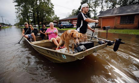
Jewel Rico and her dog Chico are rescued from flood waters from hurricane Isaac in Reserve, Louisiana. Photograph: Chris Graythen/Getty Images
Strengthened levees may have saved New Orleans from catastrophe as hurricane Isaac swept through Louisiana, but residents of outlying areas believe the city's upgraded defenses contributed to the flooding that wrecked their homes.
Outside the protection of the costly new federal shield that rings the city, some flood barriers were overwhelmed and, in scenes reminiscent of Katrina, many people had to be rescued from rooftops as floodwaters submerged their streets.
Some of those whose homes were damaged claimed that New Orleans's upgraded levees had done them more harm than good.
"We've never got caught like this, right there where I was at my house. In Katrina I never had no water – never got none in the house. This time, here, eight feet of water," said Jimmie Hutchinson, of Braithwaite, a town in Placquemines parish that was almost completely swamped when water spilled over a levee that was supposed to protect the community.
Isaac plowed inland on Thursday, causing fresh flooding and power outages in Louisiana and Mississippi and prompting emergency evacuations and warnings, even as New Orleans began its post-hurricane clean-up. About 500 people had to be rescued by boat, and there were at least two deaths.
Officials began releasing a water dam at a lake near the Louisiana-Mississippi border, hoping to ease the pressure. They were also working on a breach in Plaquemines Parish. As Isaac moved north, power lines were downed and trees knocked over.
The region to the north of New Orleans was badly affected, with numerous roads impassable in Slidell and surrounding areas.
Businesses bordering Lake Pontchartrain off Interstate 10 were under several feet of water, cars had been abandoned and mobile homes detached from their foundations. While winds were light, heavy rain continued Thursday afternoon, making driving difficult and hampering attempts to restore electricity.
Residents of Braithwaite,on the east bank of the Mississippi less than 15 miles from central New Orleans, sought refuge in attics and were rescued from rooftops by boat after floods engulfed the area. They were taken to the lesser-affected town of Belle Chasse, a short distance away on the other side of the Mississippi.
Louisiana senator Mary Landrieu said this week that there were political squabbles over funding and location of flood defenses after Katrina and expressed regret that the federal system was not more comprehensive. In some cases, outlying regions have had to organize and fund their own protective measures.
"Unfortunately … low-lying areas outside the federal system, in particular lower Jefferson and Plaquemines parishes [were hit]," she told CNN. The coast's refineries are vital to the US oil industry. "Hurricane Isaac has reinforced for us once again just how vulnerable these critical areas are. We must re-engage the Corps of Engineers on this," she said.
After Katrina, the federal government allocated about $14.5bn to the US Army Corps of Engineers to improve hurricane defenses in New Orleans. The system is largely complete save for some planned drainage improvement work.
St Bernard Parish was badly hit by Katrina but escaped serious damage this time thanks to significant upgrades including doubling the height of its levee and adding concrete walls to replace the old dirt structure. Its defenses were not breached.
Braithwaite's levee, however, is not part of the federal system and is maintained by Plaquemines parish. That will change, after the Army Corps of Engineers signed an agreement earlier this month that will see $1.4bn spent on taking control of non-federal levees and improving them. Work was planned to start in September but the accord came too late for those left homeless this week.
Residents whose homes were badly damaged told the Guardian that they believed the new levees in an adjacent parish had contributed to the unexpected flooding of their neighborhoods as the repelled water was pushed towards lower and weaker defenses.
"They've got floodgates over there that King Kong couldn't get out of, around St Bernard," Jinx Easley said. "We've been fighting over 30 years for the levees."
Jimmie Hutchinson said: "Them levees ain't no good at all. Especially with the new levees around St Bernard, new waters and all that, it just funnels in on us. And our levee's not federalized." Like others in Plaquemines parish, he ignored a mandatory evacuation order. He rode out Katrina with few problems and as a result had not expected a far less powerful hurricane such as Isaac to cause any serious issues.
Inside a YMCA in Belle Chasse that had become a shelter for last-minute evacuees, Zonia Guillot said her house had been similarly affected. It came as a shock because when her family moved the short distance from St Bernard to Plaquemines after Katrina they thought they were moving to a safer area.
"We went through the same thing with Katrina but we were in St Bernard Parish when that happened and we bought on this side thinking that it'd be better," she said.
"I think this was worse because Katrina, we only had four feet of water, we were able to save a lot of things. This time, it went over the house. The levee wasn't strong enough. They put a deep levee for St Bernard and that got us in a hole made of water."
A spokeswoman for the Army Corps of Engineers said that its defenses had been designed to have a "negligible" impact on areas outside the perimeter. "The system built post-Katrina was heavily studied and modeled for that reason, to make sure it wouldn't have any additional impacts to areas outside the system," she said.
A lack of co-ordination among local communities and state and national authorities had been evident until recently, according to Professor Robert A Thomas, director of the Center for Environmental Communication at Loyola University. "Until the beginning of the summer we didn't have what I would call a 'coastal-wide plan'" for protecting at-risk areas, he said.
Thomas added that disparate needs meant it was hard to strike a balance between economic, environmental and cultural forces when deciding how best to protect and exploit the Louisiana coastline. "I'm not saying parishes have made mistakes," he said. "[But] as long as we have parishes making individual decisions that are not linked to the overall plan you are at risk of having failures."
http://hosted.ap.org/dynamic/stories/I/ISAAC?SITE=AP&SECTION=HOME&TEMPLATE=DEFAULT&CTIME=2012-08-29-23-31-31
WEAKENING ISAAC HOVERS OVER WATER-LOGGED LOUISIANA
| |||||||||||
NEW ORLEANS (AP) -- Isaac hovered over Louisiana for a third day Thursday, shedding more than a foot of additional rain that forced authorities to hurriedly evacuate areas ahead of the storm and rescue hundreds of people who could not escape as the rapidly rising waters swallowed entire neighborhoods.
The huge spiral weather system weakened to a tropical depression as it crawled inland, but it caught many places off guard by following a meandering, unpredictable path. The storm's excruciatingly slow movement meant that Isaac practically parked over low-lying towns and threw off great sheets of water for hours.
"I was blindsided. Nobody expected this," said Richard Musatchia, who fled his water-filled home in LaPlace, northwest of New Orleans.
Inside the fortified levees that protected New Orleans, bursts of sunshine streamed through the thick clouds, and life began to return to normal. But beyond the city, people got their first good look at Isaac's damage: Hundreds of homes were underwater. Half the state was without power. Thousands were staying at shelters.
And the damage may not be done. Even more rain was expected in Louisiana before the storm finally drifts into Arkansas and Missouri.
Isaac dumped as much as 16 inches in some areas, and about 500 people had to be rescued by boat or high-water vehicles. At least two deaths were reported.
Five feet of water poured into Musatchia's home before a neighbor passed by with a boat and evacuated him and his 6-year-old boxer, Renny.
He piled two suitcases, a backpack and a few smaller bags onto the boat and said that was all he had left. He abandoned a brand-new Cadillac and a Harley-Davidson.
"People have their generators, because they thought the power would go out, but no one expected" so much water, Musatchia said.
Other evacuees were picked up by National Guard vehicles, school buses and pickup trucks.
Daphine and David Newman fled their newly decorated home with two trash bags of clothing. They have lived in their subdivision since 1992 and never had water in their home from previous storms, not even Hurricane Katrina.
The comparison was common since Isaac hit on the seventh anniversary of the devastating 2005 storm, though the differences were stark.
Katrina was more powerful, coming ashore as a Category 3 storm. Isaac was a Category 1 at its peak. Katrina barreled into the state and quickly moved through. Isaac creeped across the landscape at less than 10 mph and wobbled constantly.
David Newman was frustrated that the government spent billions of dollars reinforcing New Orleans levees after Katrina, only to see the water inundating surrounding regions.
"The water's got to go somewhere," he said. "It's going to find the weakest link."
The sudden call for evacuations so long after the storm made landfall provoked a debate about whether anyone was to blame.
Jefferson Parish Council President Chris Roberts said forecasters at the National Hurricane Center in Miami needed a new way of measuring the danger that goes beyond wind speed.
"The risk that a public official has is, people say, `Aw, it's a Category 1 storm, and you guys are out there calling for mandatory evacuations,'" Roberts said.
Hundreds of people in lower Jefferson chose to ride out the storm - and many of them had to be rescued, he said.
Eric Blake, a specialist at the hurricane center, said that although Isaac's cone shifted west as it zigzagged toward the Gulf Coast, forecasters accurately predicted its path, intensity and rainfall. He did say the storm came ashore somewhat slower than anticipated.
Blake cautioned against using Katrina as a benchmark for flooding during other storms.
"Every hurricane is different," Blake said. "If you're trying to use the last hurricane to gauge your storm surge risk, it's very dangerous."
Along the shores of Lake Ponchartrain near New Orleans, officials sent scores of buses and dozens of high-water vehicles to help evacuate about 3,000 people as floodwaters lapped against houses and stranded cars.
The water rose waist-high in some neighborhoods, and the Louisiana National Guard worked with sheriff's deputies to rescue people stuck in their homes.
In LaPlace, a Coast Guard helicopter plucked a couple and their dogs from a home after storm surge gushed into their neighborhood and washed many houses away.
"They used a flashlight inside the house as a signaling device, which made all the difference in locating them effectively," Lt. Cmdr. Jorge Porto said.
Crews intentionally breached a levee that was strained by Isaac's floodwaters in southeast Louisiana's Plaquemines Parish, which is outside the federal levee system. At the same time, water at a dam farther north in Mississippi was released in an effort to prevent flooding there.
Since the storm arrived in the U.S., the first two fatalities were a tow truck driver hit by a tree that fell on his vehicle in Picayune, Miss., and a man who fell from a tree while helping friends move a vehicle. Deputies did not know why he climbed the tree.
Although New Orleans' bigger, stronger levee system easily handled the deluge from Isaac, rural areas beyond the city's fortifications had few defenses.
Isaac "has reinforced for us once again just how vulnerable these critical areas are," said Louisiana Sen. Mary Landrieu. "We must re-engage the Corps of Engineers on this."
More than 900,000 homes and businesses around the state - about 47 percent of all customers - were without power Thursday. Utility company Entergy said that included about 157,000 in New Orleans.
New Orleans' biggest problems seemed to be downed power lines, scattered tree limbs and minor flooding.
In Mississippi, several coastal communities struggled with all the extra water, including Pascagoula, where a large portion of the city flooded and water blocked downtown intersections.
High water also prevented more than 800 people from returning to their homes in Bay St. Louis, a small town that lost most of its business district to Katrina's storm surge.
Even though Isaac was weaker, Mayor Les Fillingame said, "every storm is somebody's Katrina, regardless of the intensity."
|

http://twitchy.com/2012/08/29/worse-than-katrina-pics-of-plaquemines-parish-where-rising-floods-strand-residents/?utm_source=autotweet&utm_medium=twitter&utm_campaign=twitter
( Keep the folks in Plaquemines in your prayers - ironic on August 29th , another levee problems occurs in the New Orleans vicinity...


Isaac will exit the New Orleans area slowly tomorrow, leaving behind flooded homes, downed trees and thousands without electricity
Published: Wednesday, August 29, 2012, 5:15 PM Updated: Wednesday, August 29, 2012, 5:26 PM
Tropical Storm Isaac will slowly exit southeast Louisiana on Thursday, but its outer bands promise to continue their drenching ways well into Thursday evening and possibly overnight, accompanied by slowly weakening winds, according to the National Hurricane Center.
View full sizeTropical Storm Isaac's forecast path takes it northwest across Louisiana.
The center's 4 p.m. forecast called for Isaac to remain a tropical storm as its center reaches Baton Rouge late Wednesday night and southwest of Monroe by 1 p.m. Thursday. It will have weakened into a tropical depression by 1 a.m. Friday as the center reaches southwest Arkansas, and become a post-tropical depression by Saturday afternoon as it moves through central Missouri
"Since Isaac will continue to move slowly over the next 24-36 hours, there will be a prolonged threat of flooding from heavy rains over the northern Gulf Coast area and the south-central United States," said center Senior Hurricane Specialist Stacy Stewart in a Wednesday afternoon forecast message.
Heavy rains dumped across semicircles of the New Orleans area during the day Wednesday, prompting a series of flash flood warnings from the Slidell office of the National Weather Service and causing rising waters that required the rescue of stranded residents in a LaPlace neighborhood.
View full sizeIsaac's rainfall continues to pose a threat to much of Louisiana
Storm surge pressing inland on both the east and west sides of the Mississippi River threatened several communities. In eastern Plaquemines Parish, an 18-mile stretch of parish-built, non-federal levee between Braithwaite and White Ditch was overtopped, forcing neighbors and emergency officials to scramble in boats to rescue more than 30 people from rapidly rising water.
Rising surge waters also moved in on the Lafitte, Jean Lafitte and Barataria communities on the West Bank in Jefferson Parish.
In both cases, the surges prompted rebukes of the Army Corps of Engineers by Gov. Bobby Jindal and other state and local officials for delays of levee construction projects that may have protected the communities.
The wide circulation of the slowly weakening storm will mean water levels could remain high today in coastal locations that have been hammered with storm surges of as much as 12 feet during the past two days.
Late Wednesday, several Northshore communities along Lake Pontchartrain watched as rainwaterwater draining into the lake slowly moved easward and combined with westward-moving surge water entering the lake. High water already was causing flooding problems in Palm Lake Wednesday night.
The strong rainbands associated with the storm will only slowly move out of the area today, forecasters say, leaving behind dramatic rainfall totals.
According to the WeatherBug weather service, by 4 p.m. Wednesday, rainfall totals had reached nearly 10 inches over Tuesday and Wednesday at New Orleans City Hall and the St. James Parish Westbank Water Plant, with the St. Charles Department of Emergency Preparedness, and Magnolia School in Jefferson Parish not far behind.
Isaac's slow westerly swing on Wednesday gave a head start to Southeast Louisiana University in Hammond for what might be another bad day today, with more than 6 inches of rain on Wednesday.
Equally problematical for employees of Entergy Corp. electric utility subsidiaries and the Northshore's Cleco Inc. will be 35 mph wind gusts that are likely to still be common in New Orleans at 1 p.m. Thursday, according to the Slidell office of the National Weather Service.
Getting workers in the air to repair the broken electric lines that had left as many as 600,000 customers without power will have to wait until the winds drop below that level.
City and parish utility workers are likely to face similar threats as they move to repair damage done by the storm, including the clearing of trees and tree limbs throughout the area.
and from Weather Underground....
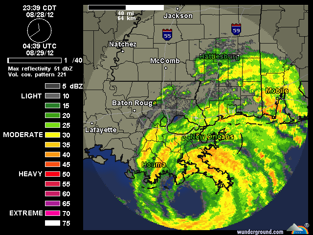
Statement as of 4:00 PM CDT on August 29, 2012
Isaac continues to trudge slowly to the northwest across
southeastern Louisiana...and the initial motion remains  310/5
kt...based on Doppler radar data from Slidell and ft. Polk
Louisiana. The model guidance has come into better agreement with
the previous official track...so no significant changes were made
for this advisory. Isaac should continue to move northwestward and
eventally northward through a weakness in the subtropical ridge
over the next 36-48 hours. By day 3 when the remnant cyclone is
over the upper-Midwest...Isaac should turn east-northeastward when
it interacts with weak mid-latitude westerly flow. The official
forecast track is just an update of the previous advisory
track...and lies between the model consensus and the ECMWF model.


Strong bands of thunderstorms continue to develop over water in the
the eastern semicircle and also southwest of the center. They have
occasionally produced sustained tropical-storm-force winds along
with gusts exceeding 60 kt. Those strong rainbands will gradually
spread westward tonight across the coastal areas of southeastern
Louisiana and southern Mississippi...including the New Orleans
metropolitan area. By Thursday night...Isaac could weaken to a
tropical depression...and it should become a Post-tropical remnant
low pressure system by Friday. There remains no indication in any
of the NHC model guidance that Isaac will be able to acquire any
baroclinic energy that could cause it to strengthen into a
significant extratropical low while it is over the United States.


Since Isaac will continue to move slowly over the next 24-36
hours...there will be a prolonged threat of flooding from heavy
rains over the northern Gulf Coast area and the south-central
United States.


National ocean service tide gages indicate that storm surge heights
of near 7 feet are still occurring along portions of the coast of
southeastern Louisiana and Mississippi.  Given the long duration


of onshore flow in these areas...water levels are expected to remain
high through tonight.


Public advisory times have reverted back to a 3-hourly cycle. The
next intermediate public advisory will be issued at 700 PM
CDT/0000z.


Forecast positions and Max winds


init  29/2100z 30.0n  91.1w   60 kt  70 mph...inland
 12h  30/0600z 30.7n  91.7w   50 kt  60 mph...inland
 24h  30/1800z 32.0n  92.6w   40 kt  45 mph...inland
 36h  31/0600z 33.8n  93.3w   30 kt  35 mph...inland
 48h  31/1800z 35.7n  93.4w   25 kt  30 mph...inland
 72h  01/1800z 38.6n  91.9w   20 kt  25 mph...Post-trop/remnt low
 96h  02/1800z 40.0n  88.0w   15 kt  15 mph...Post-trop/remnt low
120h  03/1800z 40.5n  83.5w   15 kt  15 mph...Post-trop/remnt low
Isaac continues to trudge slowly to the northwest across southeastern Louisiana...and the initial motion remains 310/5 kt...based on Doppler radar data from Slidell and ft. Polk Louisiana. The model guidance has come into better agreement with the previous official track...so no significant changes were made for this advisory. Isaac should continue to move northwestward and eventally northward through a weakness in the subtropical ridge over the next 36-48 hours. By day 3 when the remnant cyclone is over the upper-Midwest...Isaac should turn east-northeastward when it interacts with weak mid-latitude westerly flow. The official forecast track is just an update of the previous advisory track...and lies between the model consensus and the ECMWF model.Strong bands of thunderstorms continue to develop over water in the the eastern semicircle and also southwest of the center. They have occasionally produced sustained tropical-storm-force winds along with gusts exceeding 60 kt. Those strong rainbands will gradually spread westward tonight across the coastal areas of southeastern Louisiana and southern Mississippi...including the New Orleans metropolitan area. By Thursday night...Isaac could weaken to a tropical depression...and it should become a Post-tropical remnant low pressure system by Friday. There remains no indication in any of the NHC model guidance that Isaac will be able to acquire any baroclinic energy that could cause it to strengthen into a significant extratropical low while it is over the United States.Since Isaac will continue to move slowly over the next 24-36 hours...there will be a prolonged threat of flooding from heavy rains over the northern Gulf Coast area and the south-central United States.National ocean service tide gages indicate that storm surge heights of near 7 feet are still occurring along portions of the coast of southeastern Louisiana and Mississippi. Given the long durationof onshore flow in these areas...water levels are expected to remain high through tonight.Public advisory times have reverted back to a 3-hourly cycle. The next intermediate public advisory will be issued at 700 PM CDT/0000z.Forecast positions and Max windsinit 29/2100z 30.0n 91.1w 60 kt 70 mph...inland 12h 30/0600z 30.7n 91.7w 50 kt 60 mph...inland 24h 30/1800z 32.0n 92.6w 40 kt 45 mph...inland 36h 31/0600z 33.8n 93.3w 30 kt 35 mph...inland 48h 31/1800z 35.7n 93.4w 25 kt 30 mph...inland 72h 01/1800z 38.6n 91.9w 20 kt 25 mph...Post-trop/remnt low 96h 02/1800z 40.0n 88.0w 15 kt 15 mph...Post-trop/remnt low 120h 03/1800z 40.5n 83.5w 15 kt 15 mph...Post-trop/remnt low
and....
Isaac puts at least 85 percent of Jefferson, Orleans parishes into darkness
Published: Wednesday, August 29, 2012, 3:43 PM Updated: Wednesday, August 29, 2012, 4:26 PM
Hurricane Isaac has knocked out power to more than a half a million homes and businesses across southern Louisiana, with Jefferson and Orleans parishes continuing to bear the brunt of the impact through mid-day Wednesday.
EnlargeTED JACKSON / THE TIMES-PICAYUNE A young man check out a flooded Toyota Highlander left parked along the Mandeville Lakefront, floating and horn blaring as Hurricane Isaac battered Madisonville Mandeville and the northshore with high winds and high tides, Wednesday August 29, 2012.Hurricane Isaac batters the Northshore gallery (8 photos)
In Orleans Parish, which is served primarily by Entergy New Orleans, the number of power outages had exceeded 162,000 homes and businesses.
That figure was expected to soon hit a ceiling: By mid-day, at least 85 percent of the city did not have electricity, Michael Burns, an Entergy Corp. spokesman, said.
Together, Entergy New Orleans and Entergy Louisiana provide electricity service to about 186,605 customers in Orleans Parish, Burns said.
In an automated call that went out to Entergy New Orleans customers Tuesday night, Melonie Hall, director of customer service for the utility, warned that it could take 30 hours or more until the storm passes. "We want to assure you that we stand ready to restore your power as soon as it is safe to do so," Hall said in the recorded message.
That will likely take some time. While Louisiana utility companies had started bringing in extra crews by the time the first rains of Hurricane Isaac arrived in the New Orleans area to help in case strong winds brought down power lines, those gusts must subside to less than 30 miles per hour before they can be sent out to begin restoring service.
Entergy Corp. has called in about 7,000 additional line crews and contractors to repair downed lines in Louisiana and Mississippi, Burns said.
But utility crews will remain in a holding pattern at least until the winds subside.
"We're just kind of waiting for the storm to go through," Philip Allison, an Entergy New Orleans spokesman, said. "Once the storm passes, we'll start assessing damage and try to get some lights back on wherever we can."
It's difficult to predict how many more homes and businesses will lose power before Hurricane Isaac runs its course because the storm's path could still shift in any number of directions.
"We really can't do anything at this point," Allison said.
Isaac's high winds and heavy rains also caused widespread power outages elsewhere across the region, which continued to pile up throughout Wednesday.
In Jefferson Parish, which is served by Entergy Louisiana, more than 177,000 homes and businesses, or about 85 percent of its customer base, were without power.
In Bernard Parish, the number of outages neared 17,000 homes and businesses. In Plaquemines, more than 11,000 electricity customers had lost power. In Lafourche, the figure had climbed to more than 30,100.
In St. John the Baptist, almost 19,400 homes and businesses were experiencing outages; in St. Charles, the number had exceeded 17,000.
Pineville-based Cleco Power, which serves customers on the north shore, reported 54,100 outages in St. Tammany Parish by 3 p.m. Wednesday.
"Cleco has a workforce of 2,400 employees and contractors ready to restore power as soon as weather permits," Susan Broussard, a Cleco Power spokeswoman, said in an e-mail. "As long as working conditions are unsafe, our workers will be unable to begin damage assessment and power restoration."
At a 7 p.m. press conference Tuesday, New Orleans Mayor Mitch Landrieu warned residents about the dangers of approaching downed power lines. "These are serious threats, as I have said many times, can cause fatalities," Landrieu said.
http://www.bloomberg.com/news/2012-08-28/isaac-to-creep-ashore-soaking-new-orleans-on-katrina-date.html
Hurricane Isaac Whips Storm Surge On Path To New Orleans
By Matthew Brown and Brian K. Sullivan - Aug 29, 2012 6:11 AM ET
Mike Kittrell/AP Photo/Press-Register
Waves crash Tuesday, Aug. 28, 2012, in Dauphin Island, Ala., as Isaac approaches the Gulf Coast. Isaac became a hurricane.
Hurricane Isaac unleashed a storm surge of as much as 12 feet (3.7 meters) and strong winds as it pushes water over a levee on its path to New Orleans.

Aug. 28 (Bloomberg) -- Isaac reached hurricane strength as it approached the Gulf Coast and its winds started to batter New Orleans. Megan Hughes reports on Bloomberg Television's "Money Moves." (Source: Bloomberg)

Aug. 28 (Bloomberg) -- Choppy waves spill over the shoreline of Lake Pontchartrain in southeastern Louisiana as Tropical Storm Isaac approaches the region. Parts of the rain-swept Lakeshore Drive bordering the waters have been blocked off by police. Isaac, which is hovering near hurricane strength, is set to strike the Louisiana coast as early as tonight. (Source: Bloomberg)

Aug. 28 (Bloomberg) -- Storm watchers gather near the beach in Gulfport, Mississippi, in anticipation of the arrival of Hurricane Isaac. (Source: Bloomberg)

Aug. 28 (Bloomberg) -- President Barack Obama speaks at a news conference in Washington about Tropical Storm Isaac, which is nearing the Louisiana coast and hovering at the edge of hurricane strength. (Source: Bloomberg)

L'Rena Anderson leans into the wind as she walks along the beach on Okaloosa Island in Fort Walton Beach, Fla.. Anderson was among many local residents who turned out to watch the effects of Hurricane Isaac as it churns through the Gulf of Mexico toward an expected landfall in Louisiana. (AP Photo/Northwest Florida Daily News, Devon Ravine)
The storm was 20 miles (30 kilometers) southeast of Houma, Louisiana, and 50 miles south-southwest of New Orleans, the National Hurricane Center said in a report published on its website at 6:56 a.m. New York time. Isaac will probably cause “significant damage” to New Orleans, according to National Weather Service Chief Meteorologist Ken Graham.
“Isaac is skirting the coast and is half-inland, half- offshore, and as a result, has not weakened,” Graham said in a telephone interview today. “We’re going to have strong tropical-storm force winds with hurricane gusts almost all day today in some areas. You’re going to start losing trees, having more power outages and more flooding.”
The hurricane’s maximum sustained winds were 80 miles per hour, making it a Category 1 hurricane, the center said. Gusts of as much as 66 miles per hour have begun to hit Lakefront Airport in New Orleans and Boothville, Louisiana. The levee was overrun with water in Plaquemines Parish, Louisiana. New Orleans was hit by Hurricane Katrina on Aug. 29, 2005 when levees protecting the city failed, killing 1,800 people.
Plaquemines is experiencing 10-12 feet of water, Parish President Billy Nungesser told WWL Radio in an interview, according to its website. It is unknown if all residents will be able to evacuate the Braithwaite area, he said.
Entergy Corp. (ETR) said 409,000 customers in Louisiana were without power at 5 a.m. local time because of Hurricane Isaac.
The National Ocean Service reported a storm surge of 11 feet at Shell Beach, Louisiana, NHC said. Another 6.9-foot surge was reported in Waveland, Mississippi. Storm surges have reached 12 feet, according to Graham.
“We’re trying to get people to focus on the wind too,” he said. “There are major water issues, but also a lot of wind problems.”
Oil Production
Isaac has halted 93 percent of U.S. oil production in theGulf of Mexico and 67 percent of natural-gas output, and forced evacuations from 503 production platforms and 49 rigs, the Bureau of Safety and Environmental Enforcementsaid today. Six Louisiana refineries were shut and three were running at reduced rates, idling 6.7 percent of U.S. capacity, according to data compiled by Bloomberg.
Oil for October delivery fell as much as 0.9 percent to $95.44 a barrel before trading at $95.59 in electronic trading on the New York Mercantile Exchange. Gasoline for September delivery declined 1.2 percent to $3.09 a gallon.
The Gulf region is home to 23 percent of U.S. oil output, 7 percent of natural gas and 44 percent of refining capacity.
‘A lot of Rain’
“The deepest water will occur along the immediate coast in areas of onshore winds,” the advisory said. A hurricane spins counterclockwise, so the onshore winds will hit the east.
Rain may fall at a rate of 2 inches (5 centimeters) to 4 inches an hour, said John Feerick, a senior meteorologist at AccuWeather Inc. in State College, Pennsylvania.
“If the storm stays over an area for 12 hours, we’re talking a lot of rain,” he said by telephone.
From 7 to 14 inches of rain may fall and some areas may receive as much as 20 inches, the NHC said.
As that rain spreads north into farmland in Louisiana and Mississippi, that may mean trouble for some crops. Beans, cotton and rice throughout the region wait to be harvested.
“The biggest problem may be with cotton,” David Streit, an agriculture meteorologist for Commodity Weather Group LLC in Bethesda, Maryland, said by telephone. “Almost two-thirds of the cotton is open boll at this point and none of it has been harvested.”
Heavy rain can damage the quality of the cotton crop or knock the bolls off the plants, Streit said.
Drought Relief
Isaac’s rains may help in the long term to alleviate some of the drought across the Midwest, said Tom Downs, a meteorologist with Weather 2000 in New York. While it may come too late for this summer’s crops, the moisture may be enough to prepare the ground for winter planting, he said.
“It will definitely help moving forward and help to prevent this from becoming a multiyear thing,” Downs said. “This is where people got into trouble in the ’30s and the ’50s when it was back to back to back.”
A wind gust of 67 mph was reported at Lakefront airport on the south shore of Lake Pontchartrain near New Orleans, the hurricane center said at the advisory at midnight. Winds affecting the upper floors of high-rise buildings will be significantly stronger than those near ground level and could be one Saffir-Simpson category stronger at 30th floor than the ground, it said.
President Barack Obama declared an emergency for Louisiana, authorizing agencies to coordinate relief efforts. He urged residents today not to “tempt fate.”
A hurricane warning is in effect from Morgan City, Louisiana, to the Mississippi-Alabama line, including New Orleans.
Tropical Storm Kirk, the 11th named Atlantic weather system this year, is 1,220 miles east northeast of the Northern Leeward Islands and is no threat to land, the National Hurricane Center said in a separate advisory on its website at 3:31 a.m. New York time. It has maximum sustained winds of 45 miles per hour and is moving at 9 miles per hour, NHC said.
and...
http://pjmedia.com/weathernerd/2012/08/29/isaac-makes-second-louisiana-landfall/
No comments:
Post a Comment