Commentary on the economic , geopolitical and simply fascinating things going on. Served occasionally with a side of snark.
Monday, March 17, 2014
Malaysia Airline mystery March 17 , 2014 - Alternative theory from Keith Ledgerwood -- Did Malaysian Airlines 370 disappear using SIA68/SQ68 (another 777) ? And if so , might the plane that no one can find debris for actually be in Xingjian province, Kyrgyzstan, or Turkmenistan ? India fears a 9/11 type attack and continuing triple talk from Malaysian Government Officials - just make folks very nervous and distrustful !
UPDATED: Monday, March 17, 2014 - 9:00 AM ESTTypo was made during the conversion of UTC times. Meeting of SIA68 and MH320 occurred at 18:00UTC - 18:15UTC. MH320 dropped off of civilian radar at 17:22UTC.
UPDATE - Monday, March 17, 2014 - 12:15 PM ESTSome have raised the statement that TCAS doesn’t work if the transponder is disabled… this is only partially correct. Other planes TCAS would NOT see MH370 at all. MH370 would not actively query other planes as it’s transponder is off HOWEVER it could still listen to any transponder output from other planes that are actively transmitting. SQ68 would have been actively transmitting while in-range of Subang ATC center.
Even if TCAS on MH370 wasn’t working for some reason, an in-expensive portable ADS-B receiver paired with an iPad and Foreflight app would allow a pilot to receive the ADS-B output being transmitted by SQ68 at that time.
————————————————————————————————————
By: Keith Ledgerwood
As the search for missing flight Malaysian Airlines flight 370 drags on into the 10th day, so many questions continue to remain unanswered about how and why the airliner could have disappeared while seemingly under the control of a skilled pilot intent on making it invisible. With satellite pings showing where the plane could be after more than seven hours of flight, speculation has arisen that the plane could be on the ground anywhere along a path from northern Thailand to the border of Kazakhstan and Turkmenistan.
The major roadblock to this theory has been the insistence from India and Pakistan that their radar network showed no such unidentified aircraft entering or traversing their airspace. It would seem highly unlikely given such information that a Boeing 777 could indeed slip through undetected.
As a hobby pilot and aviation enthusiast, a theory began to form in my own mind on this 10thday as all of the latest information began to trickle in slowly through media outlets globally. After being unable to escape the idea that it may have happened, I began to do some analysis and research and what I discovered was very troubling to me!
Starting with a set of facts that have been made available publically and verified over the past few days, I first plotted MH370’s course onto an aviation IFR map which shows the airways and waypoints used to navigate the skies. I plotted the point where it stopped transmitting ADS-B information at 1721UTC. I then plotted the Malaysian military radar track from that point towards “VAMPI”, “GIVAL”, and then onward toward “IGREX” on P628 ending with where the plane should be at 1815UTC when military radar lost contact.
That chart looks like this:
Source: SkyVector.com
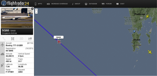
Nothing profound there… but then I looked to see what other planes were in the air at 1815UTC and I looked to see exactly where they were positioned in the sky and where they were flying. The picture started to develop when I discovered that another Boeing 777 was en-route from Singapore over the Andaman Sea.
Source: FlightRadar24.com
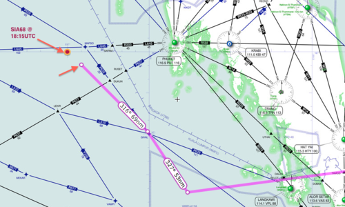
I investigated further and plotted the exact coordinates of Singapore Airlines flight number 68’s location at 1815UTC onto the aviation map. I quickly realized that SIA68 was in the immediate vicinity as the missing MH370 flight at precisely the same time. Moreover, SIA68 was en-route on a heading towards the same IGREX waypoint on airway P628 that the Malaysian military radar had shown MH370 headed towards at precisely the same time.
Source: SkyVector.com
It became apparent as I inspected SIA68’s flight path history that MH370 had maneuvered itself directly behind SIA68 at approximately 18:00UTC and over the next 15 minutes had been following SIA68. All the pieces of my theory had been fitting together with the facts that have been publically released and I began to feel a little uneasy.
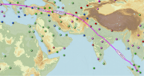
Singapore Airlines Flight 68 proceeded across the Andaman Sea into the Bay of Bengal and finally into India’s airspace. From there it appears to have proceeded across India, Pakistan, Afghanistan, and finally Turkmenistan before proceeding onward across Europe to its final destination of Barcelona, Spain.
This map depicts the approximate flight path of SIA flight 68 on that particular day. Additional detail will be required from each countries aviation authorities to establish exact particulars of the route.
Source: SkyVector.com
So by now, you may have caught on or you may be scratching your head and wondering if I’ve gone insane! How does SIA68 have anything to do with MH370 disappearing? Remember the one challenge that is currently making everyone doubt that MH370 actually flew to Turkmenistan, Iran, China, or Kyrgyzstan? That challenge is the thought that MH370 couldn’t make it through several key airspaces such as India or Afghanistan without being detected by the military.
It is my belief that MH370 likely flew in the shadow of SIA68 through India and Afghanistan airspace. As MH370 was flying “dark” without transponder / ADS-B output, SIA68 would have had no knowledge that MH370 was anywhere around and as it entered Indian airspace, it would have shown up as one single blip on the radar with only the transponder information of SIA68 lighting up ATC and military radar screens.
Wouldn’t the SIA68 flight have detected MH370? NO! The Boeing 777 utilizes a TCAS system for traffic avoidance; the system would ordinarily provide alerts and visualization to pilots if another airplane was too close. However that system only operates by receiving the transponder information from other planes and displaying it for the pilot. If MH370 was flying without the transponder, it would have been invisible to SIA68.
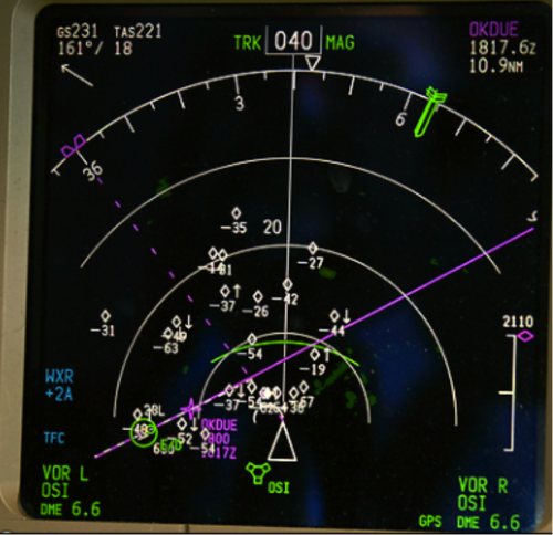
In addition, the TCAS system onboard MH370 would have enabled the pilot(s) to easily locate and approach SIA68 over the Straits of Malacca as they appeared to have done. The system would have shown them the flight’s direction of travel and the altitude it was traveling which would have enabled them to perfectly time an intercept right behind the other Boeing 777. Here is a picture of a TCAS system onboard a 777.
How does this solve the mystery??? We know MH370 didn’t fly to Spain! Once MH370 had cleared the volatile airspaces and was safe from being detected by military radar sites in India, Pakistan, and Afghanistan it would have been free to break off from the shadow of SIA68 and could have then flown a path to it’s final landing site. There are several locations along the flight path of SIA68 where it could have easily broken contact and flown and landed in Xingjian province, Kyrgyzstan, or Turkmenistan. Each of these final locations would match up almost perfectly with the 7.5 hours of total flight time and trailing SIA68. In addition, these locations are all possibilities that are on the “ARC” and fit with the data provided by Inmarsat from the SATCOM’s last known ping at 01:11UTC.
There are too many oddities in this whole story that don’t make sense if this theory isn’t the answer in my opinion. Why did MH370 fly a seemingly haphazard route and suddenly start heading northwest towards the Andaman Islands on P628? If not for this reason, it seems like a rather odd maneuver. The timing and evasive actions seem deliberate. Someone went through great lengths to attempt to become stealthy and disable ACARS, transponder/ADS-B (even though SATCOM to Inmarsat was left powered).
After looking at all the details, it is my opinion that MH370 snuck out of the Bay of Bengal using SIA68 as the perfect cover. It entered radar coverage already in the radar shadow of the other 777, stayed there throughout coverage, and then exited SIA68’s shadow and then most likely landed in one of several land locations north of India and Afghanistan.
Prime Minister Manmohan Singh (pic) promised maximum assistance in the hunt for Flight MH370, but India rejected suggestions today that it could have been the intended target of a 9/11-style attack by the missing jet. — AFP picNEW DELHI, March 17 — India rejected suggestions today that it could have been the intended target of a 9/11-style attack by the missing Malaysia Airlines jet.
As Prime Minister Manmohan Singh promised maximum assistance in the massive hunt for Flight MH370, India’s foreign minister said it was vital that the mystery over its fate was cleared up.
But asked by the CNN-IBN network about suggestions that the plane was hijacked with the aim of flying it into an Indian city, Foreign Minister Salman Khurshid replied: “I don’t think we have gone that far.”
The speculation was fuelled by former US deputy secretary of state Strobe Talbott who tweeted that the “direction, fuel load & range now lead some to suspect hijackers planned a 9/11-type attack on an Indian city”.
His comments over the weekend have been widely picked up by the Indian media and Khurshid said people needed answers to allay their fears.
“We hope to come to some conclusion that is both credible and reassuring,” he said.
The Times of India said security sources had “rubbished” the idea that the plane could have got anywhere close to an urban centre and insisted it would have been detected by a naval base on the Andaman islands, more than 1,000 kilometres (600 miles) off the Indian mainland.
“There is no way our military radars would have missed the airliner as it flew over Andaman Sea, as there is high traffic around that time,” one military intelligence source told the paper.
The US-led NATO mission in Afghanistan meanwhile said it was not looking for the missing plane there, and Islamabad’s Civil Aviation Authority said the flight never appeared on Pakistani radar.
Indian ships and planes scoured the seas off the sprawling Andamans archipelago last week but they suspended their search yesterday as they awaited fresh instructions from Malaysian authorities.
IN THE GALLERY
Residents of Boeung Kak Lake light candles to spell "MH370" during a Buddhist ceremony, praying for the missing Malaysia Airlines MH370, in Phnom Penh March 17, 2014. — Reuters pic
INTI College students having a 'Pray for MH370' candlelight vigil organised by the STACT club at INTI International University College Subang Jaya, on March 17, 2014. — Picture by Choo Choy May
INTI College students having a 'Pray for MH370' candlelight vigil organised by the STACT club at INTI International University College Subang Jaya, on March 17, 2014. — Picture by Choo Choy May
INTI College students having a 'Pray for MH370' candlelight vigil organised by the STACT club at INTI International University College Subang Jaya, on March 17, 2014. — Picture by Choo Choy May
“Operations are suspended as of now, everything is grounded,” Indian Navy spokesman D.K. Sharma told AFP today.
“Malaysian authorities will now decide and tell us where to go. They have asked us to be on standby for now.
“We are awaiting further instructions. Once we have them, we will move.”
Prime Minister Singh’s office said that his Malaysian counterpart Datuk Seri Najib Razak, in a phone call late yesterday, had requested “technical assistance from Indian authorities in corroborating the possible paths that the missing Malaysian airliner might have taken”.
Singh “assured all possible assistance from concerned Indian authorities”, the office said in a statement. — AFP
As the possibility--however remote--grows that Malaysia Airlines flight 370 may have been hijacked and taken to a hidden location, Israeli authorities are preparing for the possibility that the hijackers might attempt to use the Boeing 777 to mount an attack.
According to the Times of Israel, Israel's Channel 2 has revealed that Israeli air defenses have been boosted, and approaching civilian aircraft will be asked to identify themselves far earlier.
Though the flight was presumed at first to have crashed, whole or in pieces, into the ocean, passive satellite transmissions from the aircraft suggest that it made a deliberate course change and may have headed north into central Asia.
Pakistan has already said that the flight never registered on its radar, but at least one expert has suggested the flight could have landed in Bangladesh, whose air defenses presumably would be weaker.
Though the possibility that the Boeing 777 could be used in a terror attack is mere speculation, it is evidently being taken seriously by Israel. A plane filled with nuclear material would not need to be in Israeli airspace long to do catastrophic damage, even if shot down.
There are no reports yet that the U.S. is taking similar measures, and U.S. officials have suggested recently that the likeliest fate of flight 370 was a crash into the Indian Ocean.
And if you think Keith is half -cocked or 9/11 theories seem wacky , how much off base are these theories - when you consider the changing stories , contradictions , evasions and just dubious conduct from Malaysian Authorities ?
We’re going to wrap up our live blog coverage for the day. Here’s a summary of where things stand:
• The search for Malaysia Airlines flight 370 grew to encompass two continents, a broad swath of the Indian Ocean and the participation of 26 governments.
• Australia took the lead in search efforts in the southern Indian Ocean, dispatching surveillance and transport aircraft. In the north, aviation officials in India, Pakistan and central Asia said they had seen no sign of MH370.
• Malaysian officials said they did not know in what order the plane’s communications equipment had been turned off or disabled,throwing out a chronology seemingly established last week.
• Malaysia said the FBI and Interpol had been involved in the case from the beginning, but a senior US official was quoted as saying thatMalaysia had declined offers of an expanded US role.
• Investigators renewed their focus on the pilot of flight 370, Zaharie Ahmad Shah, and his co-pilot, Fariq Abdul-Hamid. Police have visited the homes of both men twice, Malaysian officials said.
• Family members and friends of passengers aboard MH370 expressed hope that their loved ones would be found. Tribute sites were dedicated to crew members and passengers.
Malaysian authorities have refused expanded American assistance in the hunt for MH370, an unnamed “senior American official” tells the New York Times:
In the days after the plane went missing on March 8, American investigators scoured their huge intelligence databases for information about those on board but came up dry.
“We just don’t have the right to just take over the investigation,” said a senior American official who, like others, spoke on the condition of anonymity because the investigation was continuing. “There’s not a whole lot we can do absent of a request from them for more help or a development that relates to information we may have.”
In yet another puzzling change of the official narrative, acting transport minister and minister of defence Hishammuddin Hussein revised the time of loss of communications with MH370 from 1.30 am local to 1.19 am, which would be two minutes before the last confirmed radar contact with the airliner that used a transponder to identify it to air traffic control system.
To recap, the official chronology at least until the next update appears to be that at 1.07 am the last (and unremarkable) ACARS transmission was sent from MH370, and that system was subsequently disabled at a time unknown, but which didn’t prevent it sending standby signals to a geostationary satellite over the western Indian Ocean for as long as it remained in flight or on the ground with electrical power running.
At 1.19 the last communication with MH370 was heard by Malaysia ATC which closed with the co-pilot (the airline believes) saying “all right good night”.
At 1.22 the last positive radar identification of the 777 was made using the transponder which identifies jets to air traffic control systems. Following this MH370 did not make its expected contact with Vietnam’s air traffic control system.
The transponder must have been disabled very shortly after 1.22 as no more transponder identified radar contacts were visible on either Malaysian or Vietnamese ATC screens.
These unexplained changes in timings by minister Hishammuddin Hussein threw the media update into a state of confusion for those reporters who have been trying to find consistent sense in the official narrative since regular updates began soon after MH370 ‘vanished’ from regular ATC tracking systems.
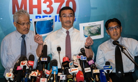
Malaysian acting transport minister Hishamuddin Hussein shows north corridor and south corridor maps with deputy minister of foreign affairs, Hamzah Zainudin and Malaysia's department civil aviation director general, Azharuddin Abdul Rahman during a media conference at Kuala Lumpur International Airport. Photograph: Azhar Rahim/EPA
Reader Michael Rhodes, a Sydney-based solicitor who says he has “extensive experience of Malaysia in particular and Malaysian Airlines” asks why the mobile phones and other communications devices of the people on board have not been traced.
In a series of emails to the Guardian he wrote:
There are 200 plus people who had mobile comms devices on the flight. Not all can have been turned off despite the strict instruction. Add to that the wild changes of altitude and direction. Going back across the Malay Archipelago, some must have established contact with ground, and lost it at variable times. Add to that, if the flight went north, other mobile towers must have acquired signals.....
Does the Andamans have any mobile towers?
Even one fleeting contact would confirm direction generally ... It seems inconceivable every single passenger switched off every single electronic device, and all of those devices remained passive as they flew through airspace with mobile phone towers seeking acquisition of mobile signals. There must be one or two forgetful people on board who left devices on. As the flight passed back over Malaysia, and in the event it went north, the mobile devices would acquire signals from ground towers, and vice versa ... My understanding is that even if mobile phones are switched off, they still ping the nearest tower to seek to acquire a network. This ping leaves a trace. You would only need 2 or 3 pings from different towers to get the trending course of the aircraft. Were it flying out of range and into the Indian Ocean, then the lack of any cell phone activity is not necessarily ominous. The lack of cell phone activity closer to land would be more ominous though for the passengers ... A number of these cell phone and their IDs must already be known- for instance those of the crew. What is being done to track these phones? They would most likely be switched off, but even then still pinging the nearest towers. They must have data of this when the flight crossed back over Malaysia at the very least.
TERRAIN MASKING: It dropped to 5,000 feet after turning back from Kuala Lumpur-Beijing route on March 8
SEPANG: MAS Airlines flight MH370 dropped to an altitude of 5,000 feet, or possibly lower, to defeat commercial (secondary) radar coverage after it turned back from its Kuala Lumpur-Beijing route on March 8.
Investigators are poring over the Boeing 777-200ER's flight profile to determine if it had flown low and used "terrain masking" during most of the eight hours it was missing from the radar coverage of possibly at least three countries.
Top officials, who make up the technical team that had been holed up from morning till late at night here, are looking at the possibility that the jetliner, carrying 239 people, had taken advantage of the busy airways over the Bay of Bengal. By sticking to commercial routes, the flight may not have raised the suspicion of those manning primary (military) radars of the nations it overflew. To them, MH370 would appear to be just another commercial aircraft on its way to its destination.
"The person who had control over the aircraft has a solid knowledge of avionics and navigation, and left a clean track. It passed low over Kelantan, that was true," said officials.
"It's possible that the aircraft had hugged the terrain in some areas, that are mountainous to avoid radar detection."
This technique is called terrain masking and is used by military pilots to fly to their targets stealthily, using the topography to mask their approach from prying microwaves. This type of flying is considered very dangerous, especially in low-light conditions and spatial disorientation, and airsickness could easily set in. The stresses and loads it puts on the airframe, especially an airliner of the 777's size, are tremendous.
"While the ongoing search is divided into two massive areas, the data that the investigating team is collating is leading us more towards the north," sources said.
Prime Minister Datuk Seri Najib Razak said the flight data showed that the plane's last communication with the satellite, reported as Inmarsat, was in one of two possible corridors: a northern corridor, stretching approximately from the border of Kazakhstan and Turkmenistan to northern Thailand; or a southern corridor, stretching roughly from Indonesia to the southern Indian Ocean.
Sources close to the investigation by a multinational team told the New Straits Times that the probe would also focus on regions with disused airports equipped with long runways capable of handling "heavies" like the Triple Seven. If anything, the area investigators could be covering has been narrowed down to MH370's eight hours of flight time, based on the jet's fuel load.
This followed MAS' confirmation of records that showed that the pilot had not made any amendments to the plane's fuel requirements. It was enough to take it to Beijing, with a 45-minute reserve in case of diversion to an alternate field.
Investigators are also factoring in the extra fuel the aircraft would have burnt in the denser lower air if it had flown "down on the deck" for sustained periods. Pilots agree that MH370 would lose up to about two hours of fuel. Any erratic manoeuvres would have also eaten into the jet's fuel reserves.
"Going by the hijacking theory, assuming it had landed, where would one hide a Boeing 777?" one said.
From about the time the aircraft made the turnback at waypoint Igari near the Vietnamese airspace, right up to the point where it left military primary radar coverage, six routine automated signals from the aircraft (known as electronic handshakes or "pings") were registered on the Inmarsat satellite network.
The last confirmed handshake was at 8.11am on Saturday, which would indicate that the aircraft continued flying for nearly seven hours after contact was lost.
Sources also confirmed that the seventh handshake never came.
"The seventh signal was sent but there has been no feedback.
"There are two likely possibilities -- either the plane landed somewhere and the engine was shut down or it crashed."
Kuala Lumpur has officially approached countries, in hopes that they would openly share and review their radar and satellite data.
It has not gone unnoticed that crucial information had been leaked and appearing in the foreign media, quoting their respective governments' sources. Such information, crucial to the search for the airplane, only came the Malaysian government's way later.
Investigators are also calculating to determine how far the aircraft may have flown and the possible landing sites.
"As soon as the first country comes up with evidence of the flight's position after its last confirmed position (320km northwest of Penang), we will be able to refine the search and better determine its possible location."
Data harvested from Inmarsat was not able to do that as the static satellite could only detect the pings at a 40o angle.
Meanwhile, another highly-placed source told the NST that initial forensics checks on Captain Zaharie Ahmad Shah's flight simulator showed that it was "clean".
However, experts are probing deeper into the footprint of the homemade simulator, which he had at his home in Shah Alam.
The same source said investigators who had opened investigation papers into the case was looking at all the passengers' backgrounds.
"The police, among others, are establishing their background and recent contacts.
"They are not leaving anything to chance and are even checking if any one of them had taken up any insurance policies recently."
A source with Malaysia Airlines, meanwhile, confirmed that both pilots were on that plane as rostered.
They had not swapped flight schedules with anyone. MAS pilots get their rosters at the end of every month.
Foreign media reports quoting a source familiar with US assessments of Inmarsat "pings" said it looked like the plane turned south over the Indian Ocean, where it would presumably have run out of fuel and crashed.
"So, its location will be extremely difficult to pinpoint.
"Without further radar/satellite/eyewitness testimony, say experts, it is very much like looking for a needle in a haystack," the reports said.
I have been watching events concerning MH320 the missing Malaysian airliner closely for the last 2 weeks, and believe I may understand what has happened.
What surprises me is nobody so far has postulated what may have happened with the evidence known. Instead wild theories about Government conspiracy and alien abduction have endured as usual.
The key and factual points show the aircraft taking off and heading towards its destination, however there appears to have been an alteration of course to the left and systems closing down on board. There also appears to have been a further 7 or so hours of the flight with a single system reporting the aircraft was still in flight.
These 7 hours were recorded as an omni directional transmission from the aircraft and detected by a satellite. And because only a single satellite received the transmission the location could not be defined.
Here is what I think has happened.
Shortly after take off a serious problem occurred, most probably an electrical fire.
This fire spread in the ducts or in a maintenance area but wasn’t detected by the aircrafts sensors, possibly because it was contained within cabling. The 777 has cables bound together in largest bundles.
Slowly and progressively the fire started to burn through cables connecting systems including communications but in the early phases of the fire the systems going down were not detected by fire sensors possibly because the cabling to the sensors was taken out first or the sensor locations couldn’t detect fire in cable bundles.
Eventually the problem was detected by the pilots but not before certain systems had mysteriously gone off line and after the final comms message, the comms failed as well.
Releasing they had a problem and no effective comms, they did what is trained, and made a left turn to return to their closest airport with good safety capabilities, e.g. Kuala Lumpur airport.
They turned left and appeared to climb to 45,000 then progressively descended to 23,000 in a number of stages. My believe is they attempted to extinguish the fire or to avoid other air traffic as systems such as radar may have been disabled also.
They continued to make a box turn to the left and headed South aiming to reach a track that would bring them South of the runway so they could make a safe return approach.
If you check the take off direction for the day it was North, so aircrafts will land into wind from the South and the left hand box turn is standard training for all pilots.
With the aircraft in autopilot and without comms and navigation, the pilots may have been trying to fight the fire or more likely trying to control the aircraft as it filled with fumes, until they were finally overcome.
At this stage the aircraft may have still been on auto pilot and the aircraft continued flying (now South) until it ran out of fuel.
The aircraft was still flying South up to 7 hours after take off and appears to have stopped transmitting at 08:11.
Therefore the aircraft is in the Southern Oceans along the curved line seen by the satellite.
As a foot note the aircraft at 35,000 feet will drop 1 foot per 15 feet travelled and therefore will be around 100 miles South of its maximum fuel range.
Its been a few weeks since I added this post and in the meantime the search has indeed switched to the South Indian Ocean. Only time will tell how accurate I have been in my assessment. How I wish I was wrong.

 Source: FlightRadar24.com
 Prime Minister Manmohan Singh (pic) promised maximum assistance in the hunt for Flight MH370, but India rejected suggestions today that it could have been the intended target of a 9/11-style attack by the missing jet. — AFP pic
 NEW DELHI, March 17 — India rejected suggestions today that it could have been the intended target of a 9/11-style attack by the missing Malaysia Airlines jet.


I have been watching events concerning MH320 the missing Malaysian airliner closely for the last 2 weeks, and believe I may understand what has happened.
ReplyDeleteWhat surprises me is nobody so far has postulated what may have happened with the evidence known. Instead wild theories about Government conspiracy and alien abduction have endured as usual.
The key and factual points show the aircraft taking off and heading towards its destination, however there appears to have been an alteration of course to the left and systems closing down on board. There also appears to have been a further 7 or so hours of the flight with a single system reporting the aircraft was still in flight.
These 7 hours were recorded as an omni directional transmission from the aircraft and detected by a satellite. And because only a single satellite received the transmission the location could not be defined.
Here is what I think has happened.
Shortly after take off a serious problem occurred, most probably an electrical fire.
This fire spread in the ducts or in a maintenance area but wasn’t detected by the aircrafts sensors, possibly because it was contained within cabling. The 777 has cables bound together in largest bundles.
Slowly and progressively the fire started to burn through cables connecting systems including communications but in the early phases of the fire the systems going down were not detected by fire sensors possibly because the cabling to the sensors was taken out first or the sensor locations couldn’t detect fire in cable bundles.
Eventually the problem was detected by the pilots but not before certain systems had mysteriously gone off line and after the final comms message, the comms failed as well.
Releasing they had a problem and no effective comms, they did what is trained, and made a left turn to return to their closest airport with good safety capabilities, e.g. Kuala Lumpur airport.
They turned left and appeared to climb to 45,000 then progressively descended to 23,000 in a number of stages. My believe is they attempted to extinguish the fire or to avoid other air traffic as systems such as radar may have been disabled also.
They continued to make a box turn to the left and headed South aiming to reach a track that would bring them South of the runway so they could make a safe return approach.
If you check the take off direction for the day it was North, so aircrafts will land into wind from the South and the left hand box turn is standard training for all pilots.
With the aircraft in autopilot and without comms and navigation, the pilots may have been trying to fight the fire or more likely trying to control the aircraft as it filled with fumes, until they were finally overcome.
At this stage the aircraft may have still been on auto pilot and the aircraft continued flying (now South) until it ran out of fuel.
The aircraft was still flying South up to 7 hours after take off and appears to have stopped transmitting at 08:11.
Therefore the aircraft is in the Southern Oceans along the curved line seen by the satellite.
As a foot note the aircraft at 35,000 feet will drop 1 foot per 15 feet travelled and therefore will be around 100 miles South of its maximum fuel range.
Its been a few weeks since I added this post and in the meantime the search has indeed switched to the South Indian Ocean. Only time will tell how accurate I have been in my assessment. How I wish I was wrong.
ReplyDelete