Friday, March 8, 2013

Louisiana Sinkhole Updates - March 8 , 2013 ....New flyover video links , video and photos ... New Information from DNR - note OXY # 1 Cavern much closer to the salt boundary ( within 200 feet ) ....... another cavern at risk of failure and perhaps another massive sinkhole ?

http://www.wbrz.com/news/jindal-not-visiting-sinkhole-will-meet-with-officials/


Jindal not visiting sinkhole, will meet with officials

Posted: Mar 8, 2013 11:27 AM
Updated: Mar 8, 2013 11:27 AM
Source: Governor's Office


BAYOU CORNE - Gov. Jindal will not visit the Bayou Corne sinkhole next week, according to his press secretary.
Sean Lansing said Friday that Jindal is scheduled to meet with officials from Assumption Parish and state agency directors on Monday to see what more can be done for people affected by the sinkhole. That meeting will take place in Baton Rouge.
Residents displaced since August have criticized the governor for never actually traveling to see the sinkhole or speak with displaced families.
Jindal said he gets constant updates from state agencies overseeing response efforts and has pledged to hold Houston-based Texas Brine accountable for the damage and to make sure people are compensated for their losses.


http://lasinkhole.wordpress.com/2013/03/11/mon-alarm/


Monday – Alarming Seismic Activity Since Overnight

Reader, Jeff warns -
The degree of seismic activity shown on heilcorder 12, 14,and 15 is shocking. For those in the area please take real notice of this and get away, get as far away as you can. This looks very bad! 45 minute event was capture last night between 6:45 and 7:30……
file -
Helicorders_March2013a

Helicorders main page

charts starting  “03/10/2013 (12)” – 
Mar11_LA12    |     Mar11_LA14   |   Mar11_LA15
UPDATE – LA14 – 1 p.m. [CST] -

For easy reference LA 12, 14 & 15 have button links on the sidebar ->


http://lasinkhole.wordpress.com/2013/03/10/texas-brine-dog-pony-show/


It’s Sunday! Texas Brine Dog & Pony Show Review is in By Erin Brockovich


The Advocate -  Brockovich takes on sinkhole case
PIERRE PART — Environmental activist Erin Brockovich told a group of Bayou Corne residents on Saturday that standing up and taking legal action against the company that owns a failed salt dome cavernbelieved to have caused the Assumption Parish sinkhole is the only way they will find relief from the emergency.
“For those of you who are there, I want you to really consider your safetyand why you’re there,” she said. “For those of you who have left, it is time to stand up and say, individually, as a community, as this homeowner, ‘I’m going to take some action,’ and that’s why we’re here.” . . . .
[snip] . . . “Girardi has offered his legal services to any resident who decides to take further action against Texas Brine and all parties responsible for their troubles over the past seven months. Brockovich says litigation, if things come to that, could take months or even years to resolve. She says her role, as it has been for nearly two decades in dozens of cases like this one, would be to keep the community united.
“We as states all over America, need to be paying more attention to what the corporations are doing…old records, what we need to do to come in and see that disaster before it happens…and not wait until after it happens and then go and argue on the legislative floor for the, what, next two or three years,” said Brockovich.”

*  *  *  *  *  *  *  *  *  * 

MM  DEQ is LOADED!


http://lasinkhole.wordpress.com/2013/03/10/dear-deq/


Dear DEQ,
 MARCH 10, 2013 BY FLYINGCUTTLEFISH
Why has there been NO area survey for radiation at Bayou Corne since Aug. 9th 2012?

Haven’t you noticed the character of the collapsed salt dome there has changed since August 9th?

In the August 9th report you found low levels of radiation (not NO levels) attributed to background level radiation by Bryan Riche, Assessment Div., LDEQ.

Isn’t it time to check again?
Are you checking the second pending sinkhole site?
Where are the monitoring logs you sent to GHOSEP? Can the public review them?
What is the source for the background level radiation?
Can you differentiate background level radiation from traces of NORM?
Besides NORM at the collapsing cavern is there TENORM?
Have inventories at all of the caverns at Assumption Parish been double-checked? Some have already been found to be in error.


Some Interesting Documents from Save Lake Peigneur


Here is something interesting.
We have put these files on our blog so the link won’t go missing.
CLICK TO VIEW
resolution


Letter from SAVE LAKE PEIGNEUR  dated March 8, 2013

to Karl Morgan, Office of Coastal Management, Baton Rouge, LA
Dear Mr. Morgan:

We received your notification of approval for the permit application for dredging in preparation for creating additional hydrocarbon storage caverns at Lake Peigneur for AGL Resources/ Jefferson Island Storage & Hub LLC. on Friday at 4:42 PM. We were not surprised by your approval since there are numerous people who have laughed at our resoluteness and belief in Louisiana’s Constitution. We have been repeatedly told, “It’s a done deal.”
There are some points that we wish to address.
Page 2 – paragraph 4: Regarding the bubbling, “the investigations completed by governmental agencies will continue to be evaluated. Any consideration from existing operations or geologic anomalies would be a consideration of the Office of Conservation when reviewing pending permit applications.”  What investigations? There have been no conclusive studies. The equipment was stolen during investigations. Our geologist clearly states in his report,  “Removal of sediment seal by the dredging operation could result in the release of a greater volume of gas bubbles from existing fractures, and the release of bubbles from new areas of Lake Peigneur.” Has Secretary Chustz reviewed this permit approval?
Dr. Losonsky’s statement clearly addresses the potential hazards to environment and human life if the dredging operation adversely exacerbates the unexplained bubbling activity. The dredging may not be the straw that breaks the camels back but at some point there will be another disaster in Lake Peigneur simply because of the unexplained bubbling.
Page 4- the discussion regarding parish resolutions, we submitted the Vermilion Parish Resolution on January 24.  Ms. Conlin and myself visited your office and provided electronically this document, again included with this letter. However, the resolutions are moot since they concern the drinking water and environmental impacts from storage cavern development.
Our attorneys requested any additional information that was provided to you from AGL Resources/JISH following the comment period. We would like that information provided to us immediately. In addition Ms. Gloria Conlin requested a copy of the video of the Public Hearing, and to date is still waiting from the appropriate individual to provide her with this video.
We would like to pick up all the documentation we submitted since we will once again need all the documents for Injection & Mining. Please let me know when we can arrange to do this.


http://theadvocate.com/home/5382504-125/concerns-raised-about-2nd-salt


Concerns raised about 2nd salt dome cavern


Second Salt Dome Cavern MapShow caption

New seismic surveys suggest a second Texas Brine Co. LLC cavern is closer to the Napoleonville Dome’s outer face than previously thought, leading the Assumption Parish sheriff to call Friday for the need to plan for emergence of a second sinkhole in the Bayou Corne area, however unlikely the possibility may be.
Also on Friday, officials announced that Gov. Bobby Jindal will meet with parish officials in Baton Rouge about the sinkhole that formed last year.
That sinkhole was discovered in early August in a swampland area between Bayou Corne and Grand Bayou after the failure of another Texas Brine cavern carved from the same part of the salt dome containing the latest cavern that is starting to raise concerns.
Scientists think the cavern that failed, known as Oxy Geismar No. 3, was mined too close to the outer face of the giant salt deposit and eventually underwent a sidewall collapse. admitting a great amount of rock strata abutting the dome. This led to the sinkhole’s formation, the release of crude oil and methane gas and the evacuation of 350 people from the Bayou Corne area for more than seven months.
Jindal is meeting with parish officials Monday amid building criticism for his decision to decline requests for a sit-down with the evacuated residents.
“The Governor is meeting with local officials from Assumption Parish and state agency directors on Monday to determine what more can be done for citizens affected by this event,” the governor’s press secretary, Sean Lansing, said by email Friday.
Assumption Parish Police Jury President Martin “Marty” Triche said he got a call from the governor’s staff on Thursday, a day after Jindal sidestepped news reporters’ questions about when he planned to meet with residents affected by the sinkhole.
“I’m anxious to meet with (the governor) on Monday whether it’s in Baton Rouge or in Bayou Corne,” Triche said.
He said he wants to talk to the governor about continued support for oversight and technical analysis as well as leaning on Texas Brine about residents’ requests for buyouts.
The new seismic testing, which the Louisiana Office of Conservation ordered Texas Brine to conduct after the failure of Oxy 3, found that the latest cavern is within 200 feet of the Napoleonville Dome’s outer wall, conservation officials said.
At that distance, the cavern, known as Oxy Geismar No. 1, would be closer to the vertical outer face of the dome than would be allowed under new minimum safety standards that the Office of Conservation is proposing in light of the earlier Texas Brine cavern failure. The proposed standard would set a minimum distance of 300 feet horizontally.
The failure of Oxy 3 is suspected of having at least a months-long build up, preceded by bubbling in area bayous and sharp earth tremors that residents reported feeling at the time.
Patrick Courreges, Office of Conservation spokesman, said the agency has been monitoring the second cavern. Measurements of its internal pressure and of nearby seismic activity do not suggest any sort of failure may be under way, he said.
“We’ve got no indication of that happening right now,” Courreges said.
The state Office of Conservation is under the state Department of Natural Resources.
Office of Conservation officials said in a statement Friday that previously ordered three-dimensional seismic tests are needed to confirm the distance between Oxy 1’s wall and the outer face of the salt dome. The other testing has a built-in margin of error.
The 3-D data must be submitted to the Office of Conservation on April 21. Monitoring will continue in the meantime, officials said.
Texas Brine and other salt dome operators use fresh water to dissolve hollow cavities from salt domes deep underground and sell the brine to industrial users. Other companies later use the cavities created by the salt brine mining process for storage of oil, gas and other hydrocarbons.
Oxy 1, which was mined for brine from 1976 to late 2011, is on the same 40-acre site as Oxy 3 and the sinkhole. Texas Brine leases the property south of La. 70 South from Occidental Petroleum Corp.
Assumption Parish Sheriff Mike Waguespack, who plans to attend Monday’s meeting with Jindal, said he wants government officials and area companies to meet to develop contingency plans for a possible “sinkhole No. 2,” however remote.
One of the sheriff’s leading concerns is possible danger posed by a second sinkhole to La. 70 South, a key thoroughfare that is about 950 feet from the Oxy 1 cavern’s outer wall.
“We’ve got to have plans in place where we can move fast,” Waguespack said. “We hope that there’s enough (monitoring in place) to have warning, but you just never know.”
The first sinkhole opened up overnight between Aug. 2 and 3 and was detected by parish officials after residents reported a strong hydrocarbon odor early on Aug. 3 as people awoke. La. 70 was shut for about 24 hours due until area pipelines could be closed.
State Rep. Karen St. Germain, D-Pierre Part, said the governor’s staff has been “very involved” in the sinkhole response. But the governor could illustrate his involvement by making a trip to Assumption Parish at some point, she said.
“It’s a great idea for him to go. He can dispel the fear that he really has not been on top of it,” St. Germain said.
Sinkhole activist John Achee Jr., who owns a camp in the area, said Jindal needs to give residents 15 to 20 minutes of his time.
“While we are pleased that after seven months he has chosen to grace our officials with his presence, we look forward to seeing him March 19 at our next community meeting on the Bayou Corne sinkhole in person,” he said.
Lansing said the governor tasked the Governor’s Office of Homeland Security and Emergency Preparedness, Louisiana State Police, the state Department of Natural Resources, the state Department of Environmental Quality and the state Department of Transportation and Development with responding to the sinkhole emergency.
“The DNR has said several times that Texas Brine should consider buyouts for residents in the evacuation area who want to leave,” Lansing said.
The Oxy 1 cavern has a cylindrical shape except at the top, where it is much wider across. This creates the overall appearance of a Roman column with an exaggerated capital at the top, a 2011 sonar survey shows.
These kinds of wider areas are called “wings” and usually result from areas where salt dissolves more easily than the rest of the cavern.
Courreges said Oxy 1’s wings are the parts of the cavern closer to the salt dome outer face than expected.
Oxy 1 is about 900 feet northeast of Oxy 3 and extends from 2,492 feet to 3,228 feet underground, shallower than Oxy 3, officials said.
Oxy 1 was the subject of a 1995 Sandia National Laboratories study that suggested the cavern might have breached the salt dome face near the cavern’s bottom. Texas Brine officials said later testing by Texas Brine argued against that conclusion.
Texas Brine spokesman Sonny Cranch said the company agrees with DNR’s assessment of the situation.


http://enenews.com/tv-concerns-about-2nd-giant-sinkhole-opening-up-salt-cavern-on-verge-of-collapsing-current-size-may-double-could-take-out-highway-70-video


Source: WBRZ
Date: March 8, 2013
h/t rainbeaudais
Anchor: [...] There are now concerns about another one forming.
Brittany Weiss, Reporter: […] Officials are saying there is a second sinkhole that is on the verge of collapsing. […]
Originally Texas Brine reported that this second salt cavern, cavern #1, no problems, but now they say that it may have problems. And we spoke with a Texas Brine representative today who says that the evidence that there was a problem with cavern #1 started months ago.
The road leading back to the Texas Brine site started tilting on one side and has been steadily sinking and bulging on the other sides. The road has since been leveled out with limestone, but workers are still on edge that the cavern could cave […]
The representative from Texas Brine said that if that salt cavern does cave in, it could essentially double the size of the sinkhole, creating a bigger problem.
It could even possibly take out Highway 70 with a couple houses as well. So we’re trying to figure out what’s being done now […]

POTENTIAL FOR 2ND CAVERN 

COLLAPSE/SINKHOLE!


http://lasinkhole.wordpress.com/2013/03/09/erin-day/


Helicorders 121415 all banging around. Does their being all in a row mean something? Map.
Helicorders_March2013a


from the comment section - Freedomrox.....


As for the line across, it is very significant, but I refuse to create a panic. Let’s just say Hooker Oil Well #1 to Oxy-Taft #9, to Occidental Water Well 4…. There is a connection.


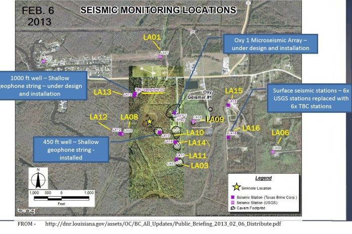
The NEW Seismo Monitor Locations


It is on P.19 of the Shaw presentation at the meeting.
Copied here -
siesmo_NEW_2013
CLICK ON IMAGE FOR FULL SIZE


DOTD has a little news posted. Highway 70 testing from this week. March 1 report.

DNR’s website has a section of Texas Brine reports. They wrote Conservation Dept. about their compliance with directives. This is a ‘daily update‘ – different than the type that appears on the Texas Brine website. It says they already have to raise the level of the new Rig Road.


Lake Peigneur

“Nara’s worried things like that could happen here if AGL Resources has their way.  They’ve proposed adding at least two more natural gas storage caverns in the salt domes of the lake.  A lake that’s recently had unexplained bubbling.”
Who is AGL? Zacks Equity Research:
“Following the acquisition of Naperville, Illinois-based Nicor Inc. in December last year, AGL Resources has become the largest domestic natural gas-only distribution entity with about 4.5 million customers across seven states.”
“Positioned in a niche industry with high barriers to entry, the company enjoys near-monopoly status in its area of operation.”


and.....


http://assumptionla.wordpress.com/2013/03/08/925-a-m-new-information-regarding-vertical-seismic-survey-from-dnr/

9:25 a.m. New Information Regarding Vertical Seismic Survey from DNR


Texas Brine has provided initial reports this week from the Office of Conservation directive issued on Dec. 7, 2012, and further revised on Jan. 14, 2013, to use vertical seismic profile imaging to help define the edge of salt near Texas Brine’s Oxy Geismar #1 and Oxy Geismar #3 caverns in conjunction with 3-D seismic imaging of the area also required by the Jan. 14 directive. Results from the 3-D seismic, required by order to be submitted by April 21, 2013, will be used to verify the accuracy of the initial vertical seismic profile results. The preliminary vertical seismic profile results Texas Brine has provided to Assumption Parish officials and the Office of Conservation indicate that the Oxy Geismar #1 cavern sidewall, which begins at a depth of approximately 2,492 feet with a base at 3,228 feet, may be within 200 feet of the salt boundary, closer than indicated by previous top-of-salt maps used to define the subsurface, though the 3-D seismic data is needed to make confirmation of that boundary distance. 
The recently completed vertical seismic profile image of the Oxy Geismar #3 cavern, making use of 2007 3-D seismic data that is available only around Oxy Geismar #3 and the 2010 vertical seismic profile done for that cavern, appears to be in close agreement with the previous imaging done for that cavern and edge of salt boundary.  The Office of Conservation-ordered 3-D seismic imaging work is currently underway to provide more detailed information regarding the relationship of the salt edges to cavern sidewalls in the area. The Oxy Geismar #1 cavern has been inactive since November 2011 and had a micro-seismic monitoring array installed in February 2013 in accordance with Conservation directives. Conservation has also required ongoing pressure monitoring in 10-second intervals, as well as seismic monitoring in the Oxy Geismar #1 wellbore and surrounding area to monitor the stability of this area through previous emergency orders issued to Texas Brine. To date, that monitoring shows no indication of instability in the structure of Oxy Geismar #1. The State’s technical experts recommend maintaining a constant cavern pressure in Oxy Geismar #1 and continuation of existing monitoring. The State’s  experts do not recommend any further action at this time. Upon completion of the 3-D seismic and ongoing analysis by the State’s technical experts and Assumption Parish Officials, a determination will be made regarding any additional actions that are necessary to protect public safety.


“”The Vertical Seismic Profile Data that has been provided to us by Texas Brine shows that Oxy Geismar Cavern #1 is closer to the outer wall of the Napoleonville Salt Dome than recently anticipated,” Assumption Parish officials have stated on their sinkhole website.”
MORE from the parish -
Oops! There goes another well pad!

14 seconds of work-road footage:

No comments:

Post a Comment