Commentary on the economic , geopolitical and simply fascinating things going on. Served occasionally with a side of snark.
Monday, January 21, 2013
Louisiana sinkhole updates - Monday January 21 , 2013 - Lake Fubar acts up over the weekend and are we on the verge of a big event there ? Great stuff from Louisiana Sinkhole Bugle and Freedom Rox....
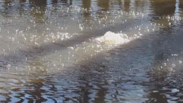
BAYOU CORNE — Eleven new bubble sites have been found in inundated swampland west of an 8.5-acre sinkhole in northern Assumption Parish, including a frothing spot dubbed the “mother of all bubble sites,” officials said Tuesday.
The sites are roughly in a row west of an unnamed oilfield access road extending south from La. 70 South through the wooded swamp, a parish map shows.
The sites bring to 34 the number of known bubble sites in the Bayou Corne and Grand Bayou areas in the vicinity of the sinkhole on Texas Brine Co. LLC’s leased property.
Scientists think the Houston-based company’s salt cavern in the Napoleonville Dome failed deep underground, causing the sinkhole and unleashing oil and natural gas from formations along the salt dome face. That free gas is thought to be surfacing through many bubble sites and the sinkhole.
Parish officials added Tuesday that the discovery has led to speculation that the row of bubbles marks the edge of a suspected subsidence zone around the outer rim of the sinkhole and also prompted officials to shift the location of a 1,000-foot-deep well that Texas Brine had been directed to drill at the end of the access road.
The well will be moved to the front of the road, officials said.
John Boudreaux, director of the parish Office of Homeland Security and Emergency Preparedness, said Shaw Environmental and Infrastructure Inc. recommended the change to avoid the possibility that the well, which will be used to collect seismic data, would be compromised in the future.
“They don’t want to make that critical mistake,” he said.
Shaw is the agent for the Louisiana Office of Conservation, which regulates salt caverns and is leading the response to the sinkhole and its side effects. Conservation Commissioner Jim Welsh ordered the well to be drilled as part of an agreement with Texas Brine earlier this month that ended the company’s lawsuit over response plans.
Boudreaux said Tuesday a representative of the landowner found the bubble sites late last week while checking the property from an airboat. He said the representative gave the frothing site the “mother of all bubble sites” moniker.
Boudreaux said the site was given the name, not for its size, but the intensity of its bubbling.
What is coming out of the new sites has not been determined yet, but Boudreaux said it can be assumed venting natural gas is causing the bubbles to emerge.
Boudreaux said Shaw and a contractor for Texas Brine collected samples from the frothing site Tuesday morning. Parish officials collected samples from another sizeable site on Sunday, Boudreaux said.
He said the other nine new bubbling sites are smaller and less intense than the other two.
The samples will undergo isotopic tests to identify the sites’ source and other tests that will show what kinds of gas are being released, such as methane or butane.
Boudreaux said the frothing site, which is about 1,100 feet west of the sinkhole, is in an area regularly covered with water, although the water depth has increased recently to about 5 feet.
He said officials said that the most-active of the bubbling sites is suspected to be arising from an old, submerged well that is serving as a conduit for the suspected gas venting. Boudreaux said soundings taken Tuesday in the bubble site hit cement.
Some bubble sites in the area preceded the formation of the sinkhole by several months but more have been discovered over time.
The first bubble sites were found in bayous in the area, under which, geologists have said, are sands that allowed for the quick transport of the “free” gas believed let loose under the Bayou Corne area.
A few bubbling sites have been found on land, sometimes when floodwaters cover previously dry ground.
Sites closest to the sinkhole have been determined to originate from this underground “formation” gas.
Sites farthest from the sinkhole have been determined to be releasing so-called “swamp gas,” which results from the decay of organic matter. Still other sites have been shown to be producing a blend of both kinds of gas.
Sinkhole: “Mother Of All Bubbles” Appears As Super Bowl Preparation Begins In Nearby New Orleans
Monday, January 21, 2013 10:23
A new bubbling site has been discovered near the sinkhole near New Orleans, Louisiana, just in time for the arrival of the Super Bowl. Termed 'the mother of all bubbles' by Office of Emergency Preparedness workers, Assumption Parish officials said the most recent bubbling site near the Bayou Corne sinkhole is the biggest pool they have seen yet.
The new bubbling site is an estimated 3,000 feet away from residences and camps.
Nick Romero, a homeowner, has seen bubbling in his yard.
"It's a little scary because now I know it's all around me," Romero said.
DOTD is monitoring LA 70 from the Bayou Corne Bridge east to LA 996. The Department is also monitoring a one-half mile stretch of LA 69 from its intersection with LA 70.
In the event conditions develop that would make the road network unusable or unsafe, we have planned the detour to be as follows:
Traffic traveling to Pierre Part and points south will be directed to LA 1 South to LA 398 West, to LA 662 West, to Hwy 90 West to LA 70.
Traffic traveling from Pierre Part and points south will be directed to US 90 East to LA 662 East, to LA 398 East, to LA 1 north to LA 70.
Local traffic (passenger vehicles and trucks below the posting of the Bayou Pigeon Bridge (15/25)) will be able to take LA 997 to LA 75 to LA 404 to LA 69.
If the order is given to close the road, DOTD crews will install trailblazing signs to notify drivers of the detour. We will also install Variable Message Signs (VMS) at LA 70 at LA 1 and LA 70 at LA 69. We will notify District 03 and they will install a VMS on LA 70 just north of Morgan City.
Residents, you can see how close the water is to Hwy 70 here. It is easier to leave while the road is intact rather than wait and have to use a detour.
More rock movements…I told you this event is not over.
It is building up for another event…mark my words.
This was not a burp, it was a belch and did a lot of damage. I would not be surprised if the salt is now laying twenty to thirty yards further west now and brining out, taking with it all the stability of the west side of the dome.
NEW Update. They are building a new access road, done measuring the VSP thing and (a miracle!) the sinkhole hasn’t changed in size! And they gave another F.U. to the press.
ASSUMPTION PARISH, LA (WAFB) - Assumption Parish officials said the most recent bubbling site near the Bayou Corne sinkhole is the biggest pool they have seen yet. Office of Emergency Preparedness workers refer to it as the “mother of all bubbles.”
The new bubbling site is an estimated 3,000 feet away from residences and camps. . . .
. . . . Sonny Cranch, a spokesman for Texas Brine said the company has obtained right-of-way agreements to start building a road which will allow them to install at least three more vent wells between Bayou Corne and the sinkhole. . . . .
Residents near Lake FUBAR – maybe take a hint and leave while hwy. 70 is intact.
LOUISIANA SINKHOLE AND PROOF LDNR AND TEXAS BRINE KNEW OXY 3 COULD FAIL IN 2010
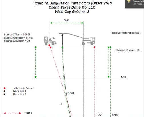
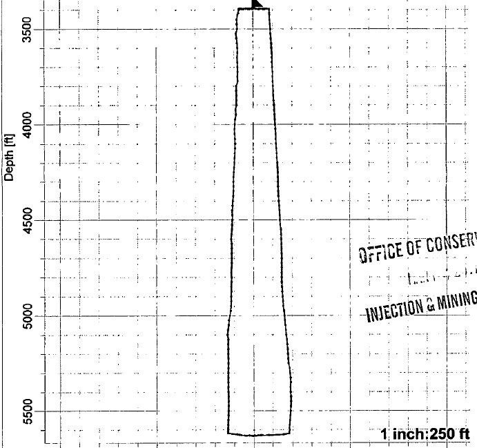
Baker Atlas conducted a Checkshot Survey and an Offset VSP Survey for Texas Brine Company Ltd. in the well Oxy Geismar 3, located in the Grand Bayou field, Assumption Parish, Louisiana. The objectives of the surveys were to:
Measure time-depth information
Image the salt flank
At the time of the survey, the well had been flushed to create a cavern below 3400ft. The surveys were performed in the borehole above this depth. A sketch of the well and possible salt location is shown as Figure 3. All measured depths are referenced to Ground Level. The well is considered vertical.
The survey began at 9:52 hrs on September 25, 2010 and was finished at 10:49 hrson September 26th, 2010.
A vibrator source was used for the surveys. One vibrator was positioned 123 ft. from the wellhead at an azimuth of 77 degrees for the checkshot survey and then two vibrators were located 3062 ft. from wellhead at an azimuth of 112 degrees for the Offset VSP survey.
A 6204XB 3-component downhole receiver was used to record the survey.
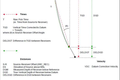
This is how they perform a VSP.
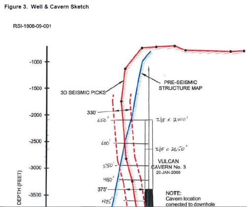
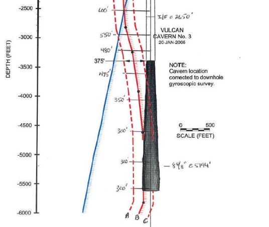
and this is the final report regarding the Oxy 3 Cavern in 2010.
Take Note, the “B” line is the 3D Seismic Pick.
Any Questions?
The full Vertical Seismic Profile can be found at:
This is the history of the salt cavern. Please take notice of when most were published by the Louisiana Dept. of Natural Resources. After the Stinkhole formed!
Even earlier SONAR scans show the bottom 1000 ft. of the cavern was compromised as shown by the almost perfect straight line, demonstrating that section was pressed against the shale sheath at the time. It would be interesting to have the drawdown records of the dates after these SONAR surveys.
SONAR Survey of Cavern 10 /06/2007, Pages 49-50 (Notice the straight line deformation showing bottom of cavern pressing against the Shale Sheath, and the Horizontal Slices show even better detail of this)
Regardless, these surveys do constitute proof that LDNR and Texas Brine both were complicit in a cover up of the gravity of the situation, years prior to the August 3rd, 2012 failure of Oxy 3 Salt Cavern.
Now we know how Mr. Hecox could honestly say, “There has been a Frack Out of the cavern.”
“Frack Out” is a term used to describe an over-pressure of fluid that overwhelms the medium within which it operates, or a failure of the medium itself, due to invasive enviromental or man-made factors.
No more proof is needed. The resident’s and their lawyers can now proceed with actions against Texas Brine, and the State of Louisiana Dept. of Natural Resources for Willful Neglect and Harm, with Malice Aforethought, and a host of other criminal and civil charges.
Below is a story video of how GeoPhones work in seismic surveys from Chevron.