http://www.nola.com/hurricane/index.ssf/2012/08/nearly_150000_power_outages_re.html
Entergy's Storm Center website, which provides updates on power outages in New Orleans and across the region, is lit up like a Christmas tree: Nearly 150,000 homes and businesses in southeastern Louisiana have been left without power, utility officials say, with Jefferson and Orleans parishes continuing to bear the brunt of the impact from the slow-moving Hurricane Isaac.
By 8 p.m., the number of power outages in Orleans Parish, which is served primarily by Entergy New Orleans, exceeded 61,000 electricity customers, up from 42,000 an hour earlier, according to the tracking website.
In an automated call that went out to Entergy New Orleans customers around 8 p.m., Melonie Hall, director of customer service for the utility, warned that it could take 30 hours or more until the storm passes. "We want to assure you that we stand ready to restore your power as soon as it is safe to do so," Hall said in the recorded message.
That will likely take some time. While Louisiana utility companies had started bringing in extra crews by the time the first rains of Hurricane Isaac arrived in the New Orleans area to help in case strong winds brought down power lines, those gusts must subside to less than 30 miles per hour before Entergy will send them out to begin restoring service.
Power outages have also occurred elsewhere across the region: In Jefferson Parish, which is served by Entergy Louisiana, more than 46,400 homes and businesses were without power, up from about 32,000 an hour earlier.
In Plaquemines Parish the number of outages had reached 9,905 homes and businesses.
In St. Bernard, 7,012 homes and businesses had been hit by outages, up from 5,072; in Lafourche, the figure had climbed to 10,102, up from 5,218.
In St. John the Baptist, 1,095 homes and businesses were experiencing outages; in St. Charles, that figure was 5,764.
Pineville-based Cleco Power, which serves customers on the north shore, reported 1,787 outages in St. Tammany Parish at about 7 p.m.
"Isaac is currently projected to make landfall Tuesday evening as a hurricane within Entergy's coastal areas," Entergy Storm Center website said in describing the outages. "We expect tropical storm conditions to start at mid-morning today in coastal Louisiana and early Wednesday morning in southern Mississippi. We have prepared our personnel and equipment to keep them safe during the storm."
At a 7 p.m. press conference, New Orleans Mayor Mitch Landrieu warned residents about the dangers of approaching downed power lines. "These are serious threats, as I have said many times, can cause fatalities," Landrieu said.
http://www.infowars.com/troops-enter-new-orleans-as-hurricane-isaac-closes-in/
Troops Enter New Orleans as Hurricane Isaac Closes In

Infowars.com
August 28, 2012
August 28, 2012
Hundreds of troops have moved into New Orleans as Hurricane Isaac has turned from a tropical storm into a hurricane.
From Reuters:
http://www.nola.com/hurricane/index.ssf/2012/08/nearly_100000_without_power_as.htmlBrandishing automatic assault rifles to ward off any threat of looting, the troops in military vehicles took up positions on mostly deserted streets. Their arrival came as driving rain and stiff winds began battering the city’s iconic French Quarter and its boarded-up storefronts.
An Infowars.com reader sent the following image of an armored vehicle patrolling the French Quarter:
It is not certain Isaac will be a repeat of Katrina. During the latter storm, the police confiscated guns, rogue cops murdered people and looted stores, and FEMA did its best to turn a bad situation into an unmitigated nightmare.

Nearly 100,000 homes and businesses in southeastern Louisiana have been left without power, utility officials say, with Jefferson and Orleans parishes continuing to bear the brunt of the impact from the slow-moving Hurricane Isaac.
By 7 p.m., the number of power outages in Orleans Parish, which is served primarily by Entergy New Orleans, had nearly reached 42,000 electricity customers, Entergy Corp., the New Orleans utility giant, said on its Entergy Storm Center website, which provides updates on power outages in New Orleans and across the region.
At a 7 p.m. press conference, New Orleans Mayor Mitch Landrieu warned residents about the dangers of approaching downed power lines. "These are serious threats, as I have said many times, can cause fatalities," Landrieu said.
In Jefferson Parish, which is served by Entergy Louisiana, more than 32,000 homes and businesses were without power, up from 8,354 at 5:35 p.m.
In Plaquemines Parish, which is served by Entergy Louisiana, the number of outages had reached 7,079 homes and businesses, up from 4,583 about an hour-and-a-half earlier.
In St. Bernard, 5,072 homes and businesses had been hit by outages, up from 3,216; in Lafourche, the figure had climbed to 5,218, up from 5,135.
Power outages have also occurred elsewhere across the region, including in St. John the Baptist Parish, 292 homes and businesses were experiencing outages; in St. Charles Parish, that figure was 3,430.
Pineville-based Cleco Power, which serves customers on the north shore, reported 1,787 outages in St. Tammany Parish at about 7 p.m.
"Isaac is currently projected to make landfall Tuesday evening as a hurricane within Entergy's coastal areas," Entergy Storm Center website said in describing the outages. "We expect tropical storm conditions to start at mid-morning today in coastal Louisiana and early Wednesday morning in southern Mississippi. We have prepared our personnel and equipment to keep them safe during the storm."
By the time the first rains of Hurricane Isaac arrived in the New Orleans area Tuesday morning, Louisiana utility companies had started bringing in extra crews to help restore power in case strong winds bring down power lines as expected.
and....
and some data / info from Tweets.........
Shell Beach, LA water level started the day @ 2 ft, now nearly 10 ft & still rising! http://ow.ly/diNFU

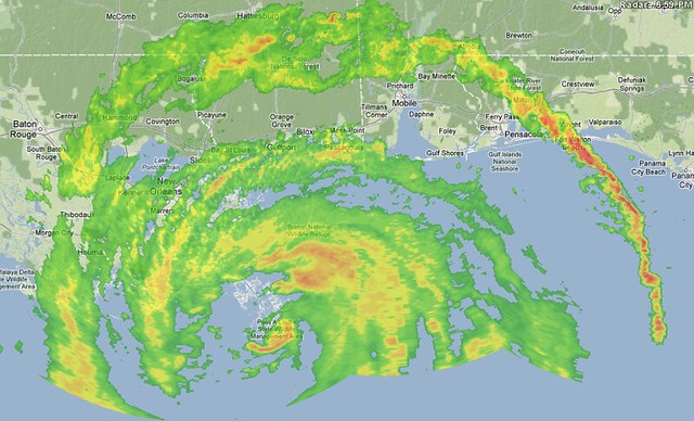
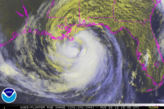
From IR Sat and latest radar,
 NWSNewOrleans
http://pjmedia.com/weathernerd/2012/08/28/isaac-makes-landfall/


http://pjmedia.com/weathernerd/2012/08/28/hurricane-isaac/
The next high tide throughout most of these areas is around midday tomorrow. (The Gulf of Mexico has diurnal tides.) On the projected track, Isaac will continue piling water onto the shore throughout the ~24-hour period between now and then. If the surge continues to prevent the tide from going out, as it’s doing right now, that next high tide could be a significant problem.
I’ve been playing down the storm surge threat a little bit, comparing it to the “hive, not pimple” phenomenon ofIke and Irene, whose surges were underwhelming as compared to the dire projections. But the trajectory of the green surge line on graphs like the one above, combined with the sheer amount of time Isaac has left to keep driving the surge on shore, has me concerned now.
[UPDATE: The National Weather Service New Orleans office is definitely concerned too. They're labeling this as a potential "extreme" surge flooding event across much of southeastern Louisiana with surge levels of 9 feet or more, which is defined as:
Life threatening flooding possible in areas outside hurricane protection levees and in areas around Lakes Pontchartrain and Maurepas. Sections of west Jefferson, east St Charles and lower Lafourche hurricane protection levees could be over topped. Areas outside of hurricane protection levees will be severely inundated. People not heeding evacuation orders in single family, one or two story homes could face certain death. Many residences of average construction directly on the coast will be destroyed. Widespread and devastating personal property damage is likely elsewhere. Vehicles left behind will likely be swept away. Numerous roads will be swamped. Some may be washed away by the water. Entire flood prone coastal communities will be cutoff, perhaps for more than a week. Water levels may exceed 9 feet or more behind over topped levees. Significant storm surge flooding will move well inland especially along bays and bayous. Coastal residents in multi story facilities risk being cutoff for a week or more.
I'm not sure what "could face certain death" means -- are they saying it "could" happen, or that it's "certain" to happen? -- but there's obviously a high level of alarm. Note, though, that the above is definitional language for an "extreme" event of 9-15 feet. It wasn't written specifically for this storm. Still. Bad news.]
The water level is also rising in and near Lake Pontchartrain. (I can’t embed that graph, alas. But go look at it!) FWIW, Katrina caused these gauges to get up in the 9 to 12 foot range.
Lots and lots more tidal and lake/river gauges here. Watch the storm surge in real time.
 Brendan Loy
Meanwhile, the storm surge is now almost 7.5 feet at Shell Beach, LA, and still climbing roughly a foot every 1.5 hourspic.twitter.com/3cQO1yAn

and.....
http://pjmedia.com/weathernerd/2012/08/28/watch-isaac-make-landfall-and-track-its-surge-live/
Tropical Storm Isaac remains at the very cusp of hurricane status, declared “nearly a hurricane” as of 7:00 AM. The most recent discussion, at 5:00 AM, stated that “THE INNER CORE CIRCULATION IS BECOMING BETTER DEFINED…AND STRENGTHENING MIGHT BE IMMINENT.” Yet for now, on the morning of the day it will hit the U.S. mainland, Isaac remains stuck at 70 mph. I confess I’m a bit surprised the NHC hasn’t just gone ahead and declared it a hurricane — it’s so close, either decision would probably be justifiable — and then let the year-end Tropical Cyclone Report retroactively downgrade it if necessary. But they’re playing this one by the book.
Whether as a 70 mph tropical storm or a 75 mph hurricane, Isaac’s effects will largely be the same. If it does start to rapidly intensify, and end up approaching Cat. 2 status, its effects will be a bit more severe. But either way, this seems likely to be a serious, but non-catastrophic, hit. (The inland flooding is the one thing that still has some potential to be catastrophic, or nearly so; we’ll see.) Folks in the storm’s path should remain hunkered down, if that’s what they’ve chosen to do, and not let down their guard. But the media should also dial back the hype, as I wrote last night. This isn’t going to morph into an apocalyptic hellstorm in the final hours before the landfall. It genuinely did have that potential, but thanks to some lucky dry air entrainment, it didn’t realize the potential, despite generally perfect environmental conditions. So now let’s not pretend a gas station roof blowing in the wind, or some predictable storm surge in an extremely flood-prone coastal area, or inevitable widespread power outages, constitutes armageddon, mmkay?
Anyway… as I did during Irene, I thought it would be helpful to post some live tidal-gauge data here, as a sort of “one-stop shop” for tracking Isaac’s storm surge. But then I realized: why stop there? How about a one-stop shop for landfall-watching generally? So, before we get to the tidal gauges, how about some satellite and radar maps?


Radar and tidal gauges on the next page.
(Or you can view this entire post — satellite, radar and tidal gagues — as a single page.)


And now for those tidal gauges, via NOAA Tides and Currents. By way of explanation/reminder:
• The blue line is the expected, “normal” water level, as the tides come in and out. Basically, it’s what the tides would be without Isaac.
• The red line is the actual observed water level. When you see the red line not declining, or only declining slightly, while the blue line is going way down, that’s bad news. It means the storm surge is preventing the tide from going out, so the next high tide will likely be much higher (assuming the surge is still present when the tide comes in).
• The green line is the “residual” level, i.e., the difference between the red and blue lines. Basically, the green line is the storm surge. So, for instance, if the red line is declining as the tide goes out, but not as much as it “should” be declining (as in the scenario just discussed), that will cause the green line to go up.
Now, on with the show… proceeding generally from west to east along the Gulf coast…
****
And here are some more charts, from the St. Charles Parish Water Level Monitoring System:


No comments:
Post a Comment